


DRONES PROTECTING TREASURED DOKDO ISLETS
입력 2019.10.25 (15:09)
수정 2019.10.25 (16:51)
읽어주기 기능은 크롬기반의
브라우저에서만 사용하실 수 있습니다.

[Anchor Lead]
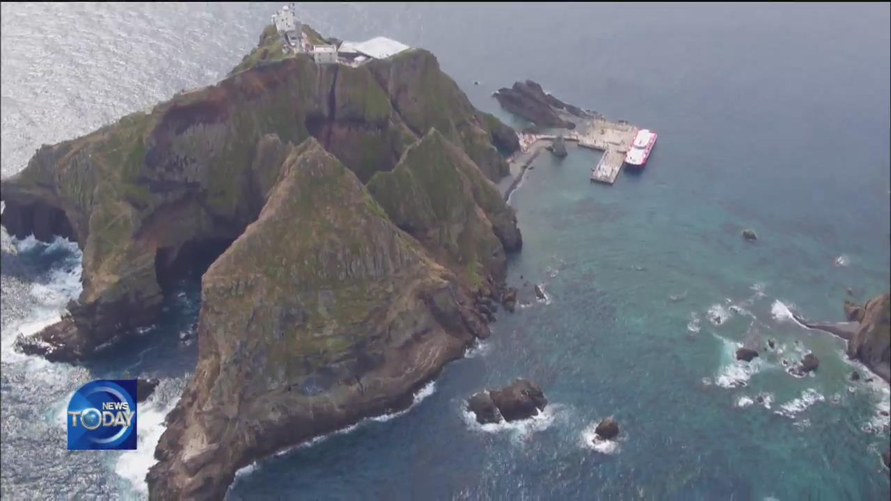
Today is Dokdo Day in Korea. The entire islets were designated an environmentally protected area but the islets' inaccessibility has made it difficult to preserve the environment. But now a super-precision drone is flying above Dokdo to monitor the islets' nooks and crannies with its laser probe.
[Pkg]
The entire islets of Dokdo were designated a naturally protected area. Colonies of the low-growing spindle tree and other rare plants are found here. The nation's easternmost island is accessible only about 40 days a year. But now a drone equipped with the LiDAR monitoring system is flying over Dokdo for the first time. LiDAR works by measuring the time it takes for a laser beam to reflect off an object. It is capable of mapping out with great precision, Dokdo's topographical contours that had previously been hard to measure due to dense vegetation. It has no problem documenting hard-to-reach places such as Cheonjanggul Cave in Dokdo's east island. The accuracy rate is very high, with a margin of error of only 15 millimeters.
[Soundbite] LEE WON-HO(CULTURAL HERITAGE ADMINISTRATION) : "We have built an important database for the preservation and management of the islets by continuously monitoring the geospatial data captured with just one flight."
This is the first time that LiDAR was utilized to take care of cultural assets. The remote sensing technology was largely used for mapping and climate observation. The LiDAR-equipped drone is expected to detect illegal structures around a cultural property as well as geographical changes following a natural disaster. The LiDAR drone, introduced for the first time for Dokdo Day, will be used to monitor landmarks and environmentally protected areas all over the nation.
■ 제보하기
▷ 카카오톡 : 'KBS제보' 검색, 채널 추가
▷ 전화 : 02-781-1234, 4444
▷ 이메일 : kbs1234@kbs.co.kr
▷ 유튜브, 네이버, 카카오에서도 KBS뉴스를 구독해주세요!
- DRONES PROTECTING TREASURED DOKDO ISLETS
-
- 입력 2019-10-25 15:15:21
- 수정2019-10-25 16:51:06
[Anchor Lead]
Today is Dokdo Day in Korea. The entire islets were designated an environmentally protected area but the islets' inaccessibility has made it difficult to preserve the environment. But now a super-precision drone is flying above Dokdo to monitor the islets' nooks and crannies with its laser probe.
[Pkg]
The entire islets of Dokdo were designated a naturally protected area. Colonies of the low-growing spindle tree and other rare plants are found here. The nation's easternmost island is accessible only about 40 days a year. But now a drone equipped with the LiDAR monitoring system is flying over Dokdo for the first time. LiDAR works by measuring the time it takes for a laser beam to reflect off an object. It is capable of mapping out with great precision, Dokdo's topographical contours that had previously been hard to measure due to dense vegetation. It has no problem documenting hard-to-reach places such as Cheonjanggul Cave in Dokdo's east island. The accuracy rate is very high, with a margin of error of only 15 millimeters.
[Soundbite] LEE WON-HO(CULTURAL HERITAGE ADMINISTRATION) : "We have built an important database for the preservation and management of the islets by continuously monitoring the geospatial data captured with just one flight."
This is the first time that LiDAR was utilized to take care of cultural assets. The remote sensing technology was largely used for mapping and climate observation. The LiDAR-equipped drone is expected to detect illegal structures around a cultural property as well as geographical changes following a natural disaster. The LiDAR drone, introduced for the first time for Dokdo Day, will be used to monitor landmarks and environmentally protected areas all over the nation.
이 기사가 좋으셨다면
-
좋아요
0
-
응원해요
0
-
후속 원해요
0
오늘의 핫 클릭
실시간 뜨거운 관심을 받고 있는 뉴스
헤드라인


이 기사에 대한 의견을 남겨주세요.