


Images of Earth
입력 2019.01.30 (15:38)
수정 2019.01.30 (15:48)
읽어주기 기능은 크롬기반의
브라우저에서만 사용하실 수 있습니다.

[Anchor Lead]
Images of Earth taken by the Cheollian Satellite 2A, which was launched into space last December, have been disclosed for the first time. Starting this summer, images sent by the satellite will be used in weather forecasts.
[Pkg]
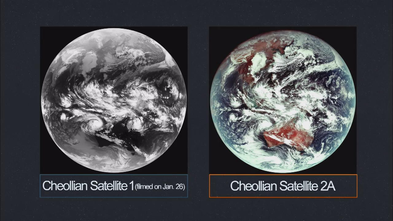
This is the first image taken by the Cheollian Satellite 2A about 36,000 kilometers from Earth. Unlike the black-and-white images of the Cheollian Satellite 1, this image shows white clouds, the red parts of land and the blue ocean. An enlarged version of the image even shows fibrous clouds brought by the cold northwestern winds. Developed using domestic technologies only, the Cheollian Satellite 2A has a resolution that is four times higher than that of the Cheollian Satellite 1. The satellite sends data about Earth every ten minutes and that of the Korean Peninsula every two minutes. This will allow meteorologists to monitor climate anomalies such as typhoons and torrential rains in real time.
[Soundbite] Choi Jae-dong(Korea Aerospace Research Institute) : "The new satellite provides more accurate, colorful images. Its speed is also significantly higher, which will probably enable it to observe typhoon paths in a more accurate way."
The new satellite will also be used to detect and analyze clouds, wildfires, smoke and volcanic ash. With the successful transmission of images from the Cheollian Satellite 2A, data sent by the satellite will likely be used in weather forecasts in earnest starting in July this year after final preparations. Meanwhile, the assembling process of a twin-satellite, the Cheollian 2B, is almost complete. The Cheollian 2B will be the first Korean satellite to have a device for monitoring air pollution. Its launch is slated for the end of this year.
Images of Earth taken by the Cheollian Satellite 2A, which was launched into space last December, have been disclosed for the first time. Starting this summer, images sent by the satellite will be used in weather forecasts.
[Pkg]
This is the first image taken by the Cheollian Satellite 2A about 36,000 kilometers from Earth. Unlike the black-and-white images of the Cheollian Satellite 1, this image shows white clouds, the red parts of land and the blue ocean. An enlarged version of the image even shows fibrous clouds brought by the cold northwestern winds. Developed using domestic technologies only, the Cheollian Satellite 2A has a resolution that is four times higher than that of the Cheollian Satellite 1. The satellite sends data about Earth every ten minutes and that of the Korean Peninsula every two minutes. This will allow meteorologists to monitor climate anomalies such as typhoons and torrential rains in real time.
[Soundbite] Choi Jae-dong(Korea Aerospace Research Institute) : "The new satellite provides more accurate, colorful images. Its speed is also significantly higher, which will probably enable it to observe typhoon paths in a more accurate way."
The new satellite will also be used to detect and analyze clouds, wildfires, smoke and volcanic ash. With the successful transmission of images from the Cheollian Satellite 2A, data sent by the satellite will likely be used in weather forecasts in earnest starting in July this year after final preparations. Meanwhile, the assembling process of a twin-satellite, the Cheollian 2B, is almost complete. The Cheollian 2B will be the first Korean satellite to have a device for monitoring air pollution. Its launch is slated for the end of this year.
■ 제보하기
▷ 카카오톡 : 'KBS제보' 검색, 채널 추가
▷ 전화 : 02-781-1234, 4444
▷ 이메일 : kbs1234@kbs.co.kr
▷ 유튜브, 네이버, 카카오에서도 KBS뉴스를 구독해주세요!
- Images of Earth
-
- 입력 2019-01-30 15:38:58
- 수정2019-01-30 15:48:04
[Anchor Lead]
Images of Earth taken by the Cheollian Satellite 2A, which was launched into space last December, have been disclosed for the first time. Starting this summer, images sent by the satellite will be used in weather forecasts.
[Pkg]
This is the first image taken by the Cheollian Satellite 2A about 36,000 kilometers from Earth. Unlike the black-and-white images of the Cheollian Satellite 1, this image shows white clouds, the red parts of land and the blue ocean. An enlarged version of the image even shows fibrous clouds brought by the cold northwestern winds. Developed using domestic technologies only, the Cheollian Satellite 2A has a resolution that is four times higher than that of the Cheollian Satellite 1. The satellite sends data about Earth every ten minutes and that of the Korean Peninsula every two minutes. This will allow meteorologists to monitor climate anomalies such as typhoons and torrential rains in real time.
[Soundbite] Choi Jae-dong(Korea Aerospace Research Institute) : "The new satellite provides more accurate, colorful images. Its speed is also significantly higher, which will probably enable it to observe typhoon paths in a more accurate way."
The new satellite will also be used to detect and analyze clouds, wildfires, smoke and volcanic ash. With the successful transmission of images from the Cheollian Satellite 2A, data sent by the satellite will likely be used in weather forecasts in earnest starting in July this year after final preparations. Meanwhile, the assembling process of a twin-satellite, the Cheollian 2B, is almost complete. The Cheollian 2B will be the first Korean satellite to have a device for monitoring air pollution. Its launch is slated for the end of this year.
이 기사가 좋으셨다면
-
좋아요
0
-
응원해요
0
-
후속 원해요
0
오늘의 핫 클릭
실시간 뜨거운 관심을 받고 있는 뉴스
헤드라인


이 기사에 대한 의견을 남겨주세요.