


REAL TIME MONITORING OF ISLETS
입력 2019.10.08 (15:06)
수정 2019.10.08 (16:44)
읽어주기 기능은 크롬기반의
브라우저에서만 사용하실 수 있습니다.

[Anchor Lead]
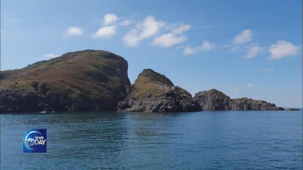
What you're looking at right now is the real time footage of Gyeongnyeolbi-yeoldo Islets which is located on the Westernmost part of Korea. They are known for their scenic beauty and great geopolitical importance. Real time footage of the islets will now be available around the clock, provided by KBS. Lets take a look.
[Pkg]
Some 55 kilometers west of Taean Peninsula in South Chungcheong Province, a distance of about a 90 minute boat ride, three islets come into view in the middle of the ocean. They are named Gyeongnyeolbi-yeoldo as they resemble the shape of wild geese flying in formation. Due to its westernmost location - in fact serving as one of the baselines for the boundary of territorial waters - the islets are nicknamed the 'Dokdo islets of the West Sea.' They are fairly off limits from any human access, enabling a pristine natural habitat for camellia tree colonies and black-tailed gulls. The islets also have geopolitical significance amid fine dust pollution originating from China and illegal Chinese fishing operations taking place in the area.
[Soundbite] PARK EUN-SEO(CULTURE & TOURISM COMMENTATOR) : "Chinese fishing boats can easily appear in this area. Here you feel an atmosphere of an unseen war over fishing grounds."
Now, real time footage of the scenic Gyeongnyeolbi-yeoldo is available nationwide thanks to KBS. The broadcaster and Taean-gun County have installed video transmission facilities there to provide high-quality images around the clock.
[Soundbite] KA SE-RO(GOVERNOR OF TAEAN) : "Gyeongnyeolbi-yeoldo is no longer solely Taean's islets, but a beloved national treasure."
KBS will use the footage for disaster news coverage, including cases such as last month's Typhoon Lingling. It will also be provided for public viewing via YouTube.
[Soundbite] SON SEUNG-GU(KBS DAEJEON) : "The real-time footage will be used in KBS disaster broadcasts including typhoons and yellow sand storms."
With the latest addition, real time images of Korea's easternmost Dokdo, southernmost Marado and now the westernmost Gyeongnyeolbi-yeoldo can all be viewed around the clock, courtesy of KBS.
■ 제보하기
▷ 카카오톡 : 'KBS제보' 검색, 채널 추가
▷ 전화 : 02-781-1234, 4444
▷ 이메일 : kbs1234@kbs.co.kr
▷ 유튜브, 네이버, 카카오에서도 KBS뉴스를 구독해주세요!
- REAL TIME MONITORING OF ISLETS
-
- 입력 2019-10-08 15:09:12
- 수정2019-10-08 16:44:38
[Anchor Lead]
What you're looking at right now is the real time footage of Gyeongnyeolbi-yeoldo Islets which is located on the Westernmost part of Korea. They are known for their scenic beauty and great geopolitical importance. Real time footage of the islets will now be available around the clock, provided by KBS. Lets take a look.
[Pkg]
Some 55 kilometers west of Taean Peninsula in South Chungcheong Province, a distance of about a 90 minute boat ride, three islets come into view in the middle of the ocean. They are named Gyeongnyeolbi-yeoldo as they resemble the shape of wild geese flying in formation. Due to its westernmost location - in fact serving as one of the baselines for the boundary of territorial waters - the islets are nicknamed the 'Dokdo islets of the West Sea.' They are fairly off limits from any human access, enabling a pristine natural habitat for camellia tree colonies and black-tailed gulls. The islets also have geopolitical significance amid fine dust pollution originating from China and illegal Chinese fishing operations taking place in the area.
[Soundbite] PARK EUN-SEO(CULTURE & TOURISM COMMENTATOR) : "Chinese fishing boats can easily appear in this area. Here you feel an atmosphere of an unseen war over fishing grounds."
Now, real time footage of the scenic Gyeongnyeolbi-yeoldo is available nationwide thanks to KBS. The broadcaster and Taean-gun County have installed video transmission facilities there to provide high-quality images around the clock.
[Soundbite] KA SE-RO(GOVERNOR OF TAEAN) : "Gyeongnyeolbi-yeoldo is no longer solely Taean's islets, but a beloved national treasure."
KBS will use the footage for disaster news coverage, including cases such as last month's Typhoon Lingling. It will also be provided for public viewing via YouTube.
[Soundbite] SON SEUNG-GU(KBS DAEJEON) : "The real-time footage will be used in KBS disaster broadcasts including typhoons and yellow sand storms."
With the latest addition, real time images of Korea's easternmost Dokdo, southernmost Marado and now the westernmost Gyeongnyeolbi-yeoldo can all be viewed around the clock, courtesy of KBS.
이 기사가 좋으셨다면
-
좋아요
0
-
응원해요
0
-
후속 원해요
0
오늘의 핫 클릭
실시간 뜨거운 관심을 받고 있는 뉴스
헤드라인

![[단독] 골프연습장 아니라더니<br>…‘한남동 골프연습장’ 도면 입수](/data/news/2025/07/01/20250701_Uh8Jnu.png)

이 기사에 대한 의견을 남겨주세요.