


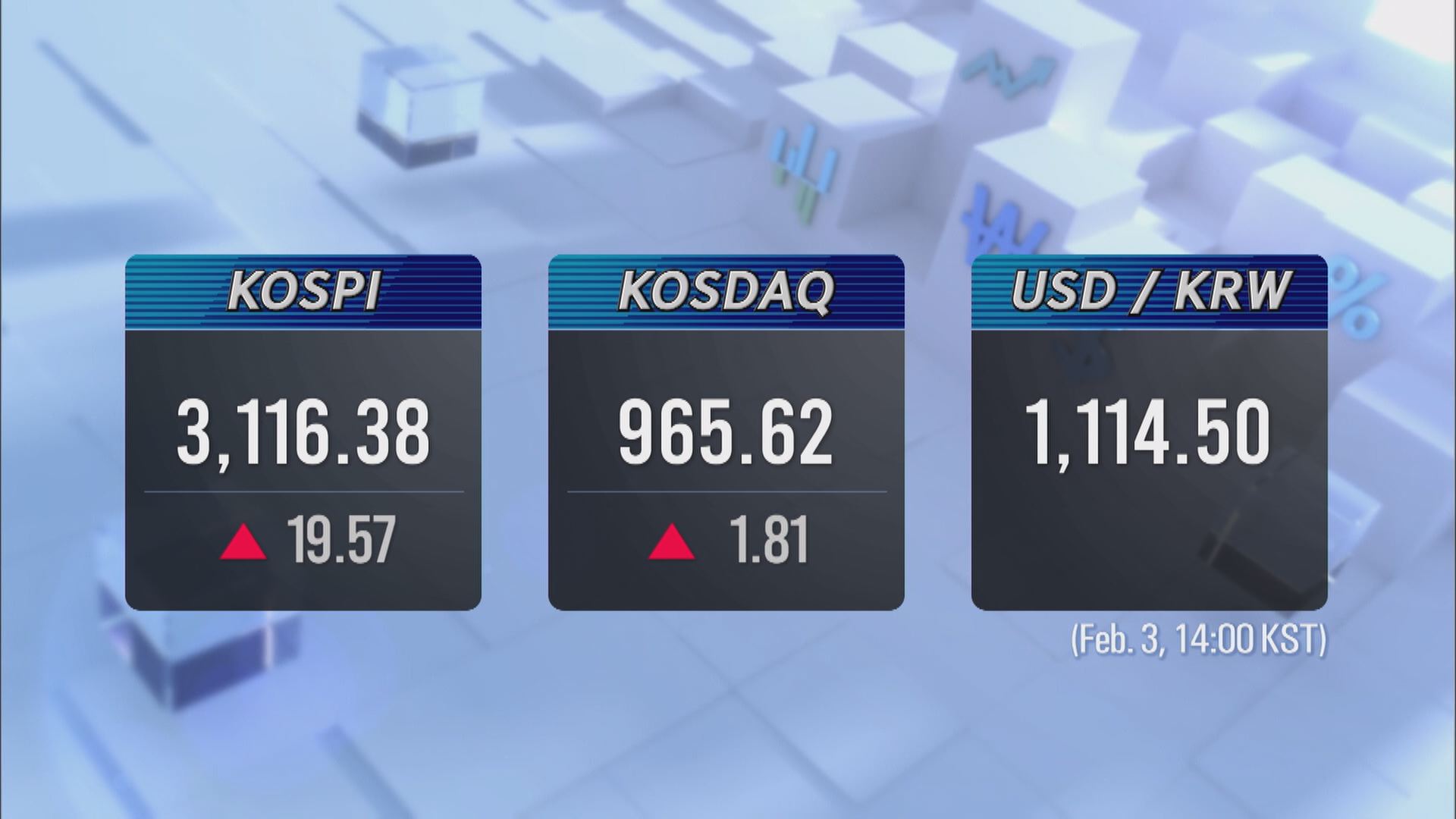
S. KOREA’S FIRST SEA NAVIGATION SERVICE
입력 2021.02.03 (15:29)
수정 2021.02.04 (07:05)
읽어주기 기능은 크롬기반의
브라우저에서만 사용하실 수 있습니다.

[Anchor Lead]
Small and big accidents frequently occur on the seas as fishing vessels mainly rely on the captain’s capabilities in navigation. The weather also throws in a curve ball. The first sea navigation service has launched, just like a navi system for cars, to help sailors with safe passage and alert them of the best route and potential risks ahead such as a collision.
[Pkg]
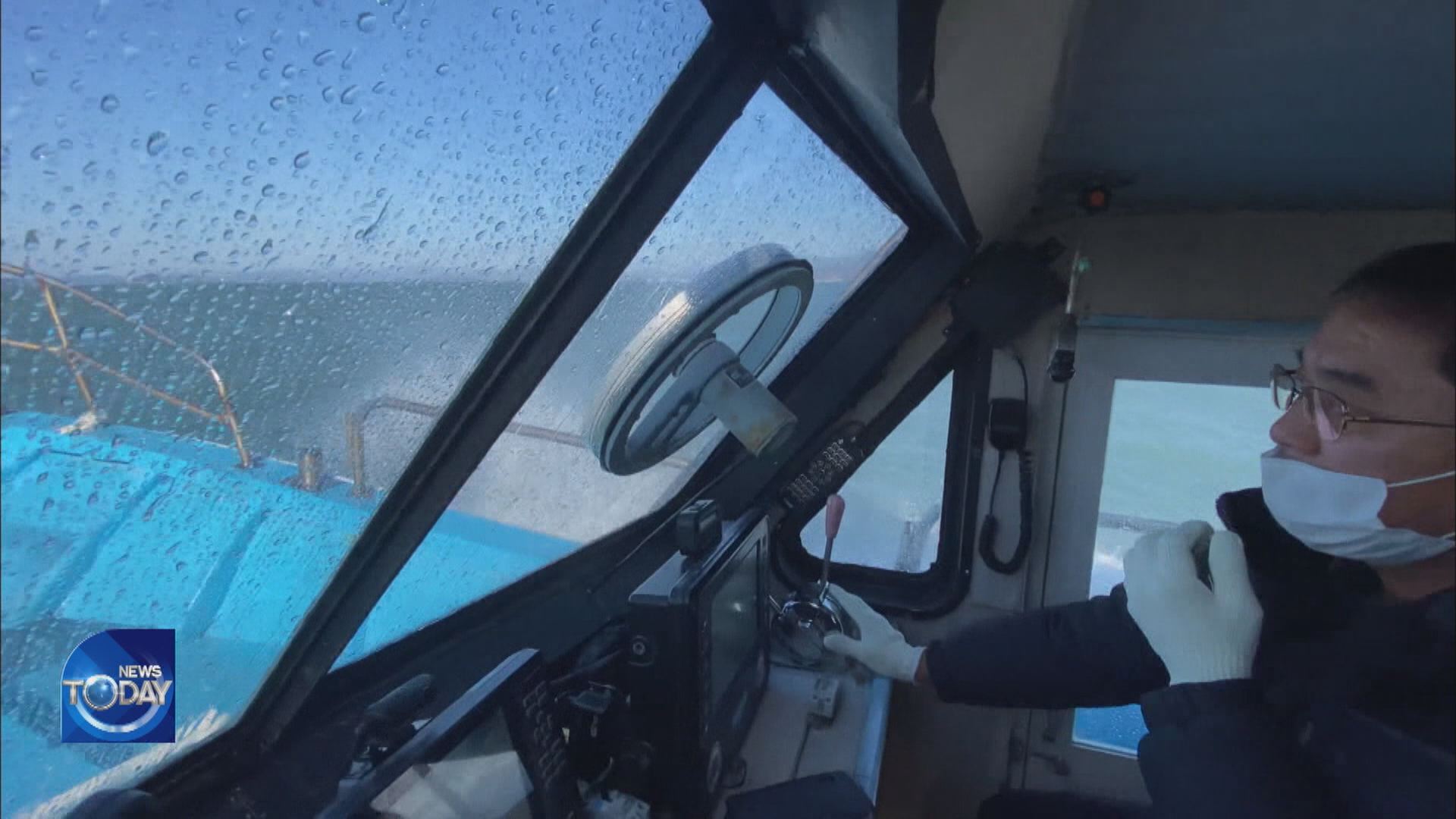
This is a fishing boat equipped with a sea navigation system. The destination is typed in and the boat sets out.
[Soundbite] “Sea route verification results received. Guidance will now begin.”
Information such as water depth and density of vessels is automatically analyzed to provide the fastest and safest sea route. The system uses an electronic navigational chart which is automated to feed in the latest information. Away from the harbor and out on sea, there are several other ships in the area.
[Soundbite] “A vessel is approaching at 0.4 kn from 2.4 km away. Please navigate safely.”
From a distance of 150 meters ahead, the system alerts the boat of possible collision and risk factors such as the location of fish farms and fishing grounds.
[Soundbite] Kim Seong-il(Fishing boat captain) : “Rather than relying on what‘s visible to the naked eye, I can check all data that appears on screen such as the location, direction and speed of other boats.”
[Soundbite] “Port entry report has been filed.”
The navigation system also files reports when entering or departing a port and a video call is immediately put through when the ship signals for help using an exclusive terminal device. This is all enabled by an ultra high speed digital communication network that incorporates 260 base stations and 620 transmitters and receivers that have been established to launch the world’s first sea navigation service. Using a mobile app, the service is available as far as 30 kilometers from the coast. With an exclusive terminal, the coverage extends to 100 kilometers.
[Soundbite] Park Jun-yeong(Busan Regional Office of Oceans & Fisheries) : “Vessels receive real-time data on the location of nearby boats as well as potential collision alerts.”
Some 400 maritime incidents occur each year including clashes and shipwrecks. The government expects the new service to help reduce accidents by 30%.
Small and big accidents frequently occur on the seas as fishing vessels mainly rely on the captain’s capabilities in navigation. The weather also throws in a curve ball. The first sea navigation service has launched, just like a navi system for cars, to help sailors with safe passage and alert them of the best route and potential risks ahead such as a collision.
[Pkg]
This is a fishing boat equipped with a sea navigation system. The destination is typed in and the boat sets out.
[Soundbite] “Sea route verification results received. Guidance will now begin.”
Information such as water depth and density of vessels is automatically analyzed to provide the fastest and safest sea route. The system uses an electronic navigational chart which is automated to feed in the latest information. Away from the harbor and out on sea, there are several other ships in the area.
[Soundbite] “A vessel is approaching at 0.4 kn from 2.4 km away. Please navigate safely.”
From a distance of 150 meters ahead, the system alerts the boat of possible collision and risk factors such as the location of fish farms and fishing grounds.
[Soundbite] Kim Seong-il(Fishing boat captain) : “Rather than relying on what‘s visible to the naked eye, I can check all data that appears on screen such as the location, direction and speed of other boats.”
[Soundbite] “Port entry report has been filed.”
The navigation system also files reports when entering or departing a port and a video call is immediately put through when the ship signals for help using an exclusive terminal device. This is all enabled by an ultra high speed digital communication network that incorporates 260 base stations and 620 transmitters and receivers that have been established to launch the world’s first sea navigation service. Using a mobile app, the service is available as far as 30 kilometers from the coast. With an exclusive terminal, the coverage extends to 100 kilometers.
[Soundbite] Park Jun-yeong(Busan Regional Office of Oceans & Fisheries) : “Vessels receive real-time data on the location of nearby boats as well as potential collision alerts.”
Some 400 maritime incidents occur each year including clashes and shipwrecks. The government expects the new service to help reduce accidents by 30%.
■ 제보하기
▷ 카카오톡 : 'KBS제보' 검색, 채널 추가
▷ 전화 : 02-781-1234, 4444
▷ 이메일 : kbs1234@kbs.co.kr
▷ 유튜브, 네이버, 카카오에서도 KBS뉴스를 구독해주세요!
- S. KOREA’S FIRST SEA NAVIGATION SERVICE
-
- 입력 2021-02-03 15:29:44
- 수정2021-02-04 07:05:59
[Anchor Lead]
Small and big accidents frequently occur on the seas as fishing vessels mainly rely on the captain’s capabilities in navigation. The weather also throws in a curve ball. The first sea navigation service has launched, just like a navi system for cars, to help sailors with safe passage and alert them of the best route and potential risks ahead such as a collision.
[Pkg]
This is a fishing boat equipped with a sea navigation system. The destination is typed in and the boat sets out.
[Soundbite] “Sea route verification results received. Guidance will now begin.”
Information such as water depth and density of vessels is automatically analyzed to provide the fastest and safest sea route. The system uses an electronic navigational chart which is automated to feed in the latest information. Away from the harbor and out on sea, there are several other ships in the area.
[Soundbite] “A vessel is approaching at 0.4 kn from 2.4 km away. Please navigate safely.”
From a distance of 150 meters ahead, the system alerts the boat of possible collision and risk factors such as the location of fish farms and fishing grounds.
[Soundbite] Kim Seong-il(Fishing boat captain) : “Rather than relying on what‘s visible to the naked eye, I can check all data that appears on screen such as the location, direction and speed of other boats.”
[Soundbite] “Port entry report has been filed.”
The navigation system also files reports when entering or departing a port and a video call is immediately put through when the ship signals for help using an exclusive terminal device. This is all enabled by an ultra high speed digital communication network that incorporates 260 base stations and 620 transmitters and receivers that have been established to launch the world’s first sea navigation service. Using a mobile app, the service is available as far as 30 kilometers from the coast. With an exclusive terminal, the coverage extends to 100 kilometers.
[Soundbite] Park Jun-yeong(Busan Regional Office of Oceans & Fisheries) : “Vessels receive real-time data on the location of nearby boats as well as potential collision alerts.”
Some 400 maritime incidents occur each year including clashes and shipwrecks. The government expects the new service to help reduce accidents by 30%.
이 기사가 좋으셨다면
-
좋아요
0
-
응원해요
0
-
후속 원해요
0
오늘의 핫 클릭
실시간 뜨거운 관심을 받고 있는 뉴스
헤드라인


![[단독] 김민석 총리, 취임 첫 일정으로 ‘송미령 반대’ 농민단체 농성장 방문](/data/news/2025/07/03/20250703_YUTdgQ.png)


이 기사에 대한 의견을 남겨주세요.