


HINNAMNOR EXPECTED TO BE ‘SUPER STRONG’
입력 2022.09.05 (15:34)
수정 2022.09.05 (16:56)
읽어주기 기능은 크롬기반의
브라우저에서만 사용하실 수 있습니다.

[Anchor Lead]
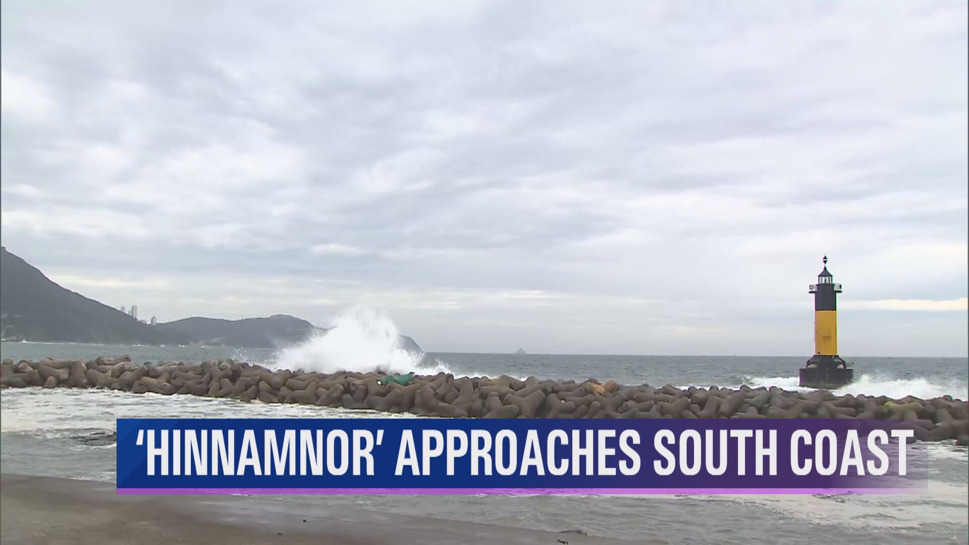
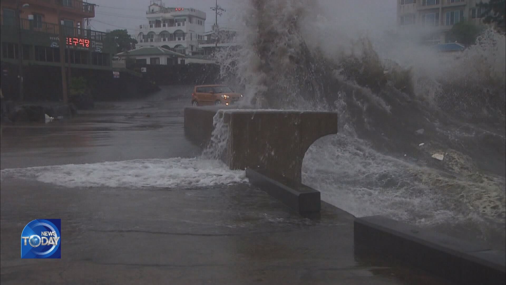
The Korea Meteorological Administration warned that approaching Hinnamnor may be a super strong typhoon that we have never experienced before. The latest typhoon is expected to slam Korea as it travels north toward the peninsula while remaining more powerful than the devastating Maemi and Rusa of the past. Let's find out more about the devastating power of Typhoon Hinnamnor.
[Pkg]
Typhoon Hinnamnor's central pressure at the time of landfall is expected to be 950 hectopascal and its maximum wind speed 43 meters per second. At a wind speed of 30 meters per second street signs will likely be knocked down and people will find it hard to walk straight. Trees may be uprooted and trains derailed. Typhoon Maemi in 2003 gusted at 40 meters per second when it made landfall. A maximum wind speed of 60 meters per second was measured in the mountains of Jeju-do Island. A transmission tower had crumpled like paper. Cranes fell on top of a fire truck, seriously injuring four firefighters. The nation's southern coast is likely to be pounded with gale force winds as it is situated to the right of the moving typhoon.
[Soundbite] Kim Seung-bae(KBS Disaster Broadcaster) : "It's moving northward along a similar route to Typhoon Sarah in 1959 and Maemi in 2003. When they made landfall in Korea's southern coast, their wind speed measured 40 to 50 m/s and their central pressure 950hPa."
Hinnamnor is also expected to bring heavy rain. In 2002, Typhoon Rusa pummeled the Gangneung region with 870.5 millimeters of rain or 62% of the area's annual average rainfall in a single day. Flood swept away houses and fields in both urban and rural areas. Roads were destroyed and mudslides occurred. The typhoon left about 50 people dead or missing in Gangneung alone and caused 800 billion won in property damage. This time, the entire country will be in Hinnamnor's grip. Tsunami damage is also likely. Wind gusts brought on by the typhoon will cause tsunami-like waves along the shores and seawater will flood places generally considered safe. Extensive flooding could occur when water doesn't recede from inland areas experiencing high seawater level on top of torrential rain. Hinnamnor is likened to the worst typhoons of the past such as Sarah, Rusa and Maemi, which had left hundreds of casualties and more than four trillion won in property damage.
■ 제보하기
▷ 카카오톡 : 'KBS제보' 검색, 채널 추가
▷ 전화 : 02-781-1234, 4444
▷ 이메일 : kbs1234@kbs.co.kr
▷ 유튜브, 네이버, 카카오에서도 KBS뉴스를 구독해주세요!
- HINNAMNOR EXPECTED TO BE ‘SUPER STRONG’
-
- 입력 2022-09-05 15:34:11
- 수정2022-09-05 16:56:13
[Anchor Lead]
The Korea Meteorological Administration warned that approaching Hinnamnor may be a super strong typhoon that we have never experienced before. The latest typhoon is expected to slam Korea as it travels north toward the peninsula while remaining more powerful than the devastating Maemi and Rusa of the past. Let's find out more about the devastating power of Typhoon Hinnamnor.
[Pkg]
Typhoon Hinnamnor's central pressure at the time of landfall is expected to be 950 hectopascal and its maximum wind speed 43 meters per second. At a wind speed of 30 meters per second street signs will likely be knocked down and people will find it hard to walk straight. Trees may be uprooted and trains derailed. Typhoon Maemi in 2003 gusted at 40 meters per second when it made landfall. A maximum wind speed of 60 meters per second was measured in the mountains of Jeju-do Island. A transmission tower had crumpled like paper. Cranes fell on top of a fire truck, seriously injuring four firefighters. The nation's southern coast is likely to be pounded with gale force winds as it is situated to the right of the moving typhoon.
[Soundbite] Kim Seung-bae(KBS Disaster Broadcaster) : "It's moving northward along a similar route to Typhoon Sarah in 1959 and Maemi in 2003. When they made landfall in Korea's southern coast, their wind speed measured 40 to 50 m/s and their central pressure 950hPa."
Hinnamnor is also expected to bring heavy rain. In 2002, Typhoon Rusa pummeled the Gangneung region with 870.5 millimeters of rain or 62% of the area's annual average rainfall in a single day. Flood swept away houses and fields in both urban and rural areas. Roads were destroyed and mudslides occurred. The typhoon left about 50 people dead or missing in Gangneung alone and caused 800 billion won in property damage. This time, the entire country will be in Hinnamnor's grip. Tsunami damage is also likely. Wind gusts brought on by the typhoon will cause tsunami-like waves along the shores and seawater will flood places generally considered safe. Extensive flooding could occur when water doesn't recede from inland areas experiencing high seawater level on top of torrential rain. Hinnamnor is likened to the worst typhoons of the past such as Sarah, Rusa and Maemi, which had left hundreds of casualties and more than four trillion won in property damage.
이 기사가 좋으셨다면
-
좋아요
0
-
응원해요
0
-
후속 원해요
0
오늘의 핫 클릭
실시간 뜨거운 관심을 받고 있는 뉴스
헤드라인
![[단독] “윤석열·김용현 등 공모해 군사상 이익 해쳐”<br>…외환죄 대신 일반이적죄 적용](/data/layer/904/2025/07/20250714_3VTJV3.jpg)


이 기사에 대한 의견을 남겨주세요.