


DESTRUCTIVE POWER OF HINNAMNOR
입력 2022.09.07 (15:08)
수정 2022.09.07 (16:45)
읽어주기 기능은 크롬기반의
브라우저에서만 사용하실 수 있습니다.

[Anchor Lead]
Typhoon Hinnamnor was initially forecast to be as destructive as Typhoon Maemi, which hit Korea in 2003. But was it indeed? Let's take a look
[Pkg]
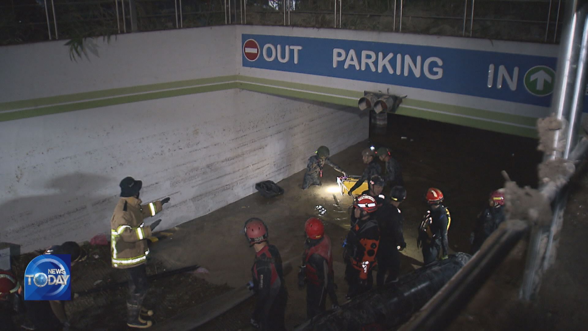
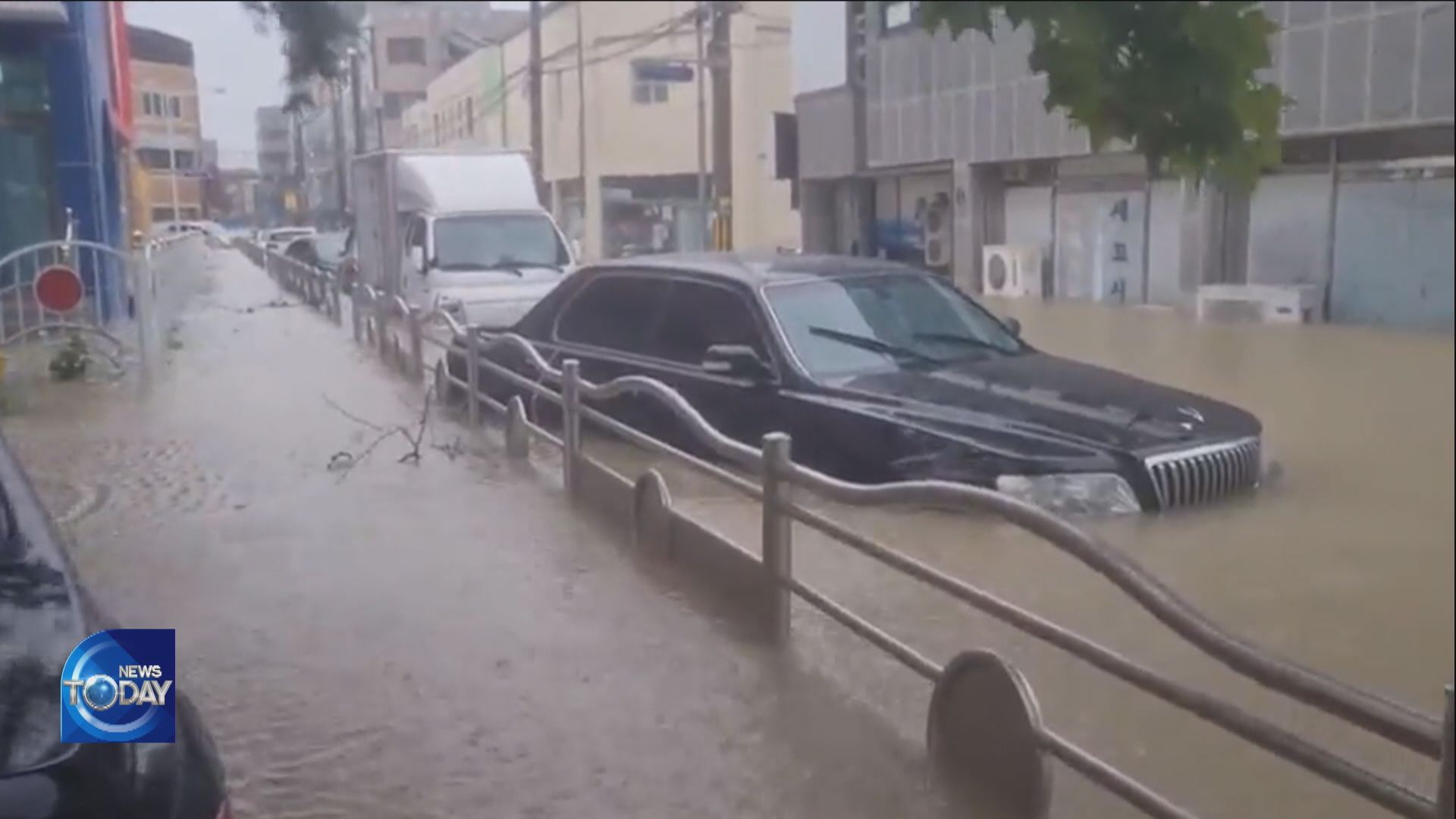
When Pohang was hit by torrential rain at dawn on Tuesday, belt-shaped clouds were spotted by a radar to the north of the typhoon's whirlpool. They hovered in the skies over Pohang for over three hours, dumping heavy rain on the city, even though the typhoon itself had moved to the northeast. The Korea Meteorological Administration says the hourly precipitation was 111mm. Over in Donghae-myeon of Pohang, the amount of rainfall exceeded 500mm in just eight hours.
[Soundbite] Lee Kwang-yeon(Korea Meteorological Administration) : "The clash between the hot and humid air brought by the typhoon from the southeast and the cold and dry air from the west resulted in the formation of strong belt-shaped clouds."
As a result, most of the casualties caused by Hinnamnor occurred on the east coast of the southeastern region or Yeongnam, where strong rain clouds stayed for a long time. It was different from Typhoon Maemi, which brought gusty winds that wreaked havoc on the entire country. Back then, casualties occurred not only in the Yeongnam region, where the eye of the storm passed, but also in Jeju, southwestern region or the honam area and Gangwon-do Province. Experts concluded this is due to a slight difference in the two typhoons' routes. Maemi made landfall in Sacheon, Gyeongsangnam-do Province and passed through the inland area for about seven hours before escaping through Uljin, Gyeongsangbuk-do Province. By contrast, Hinnamnor made landfall in Geoje and headed to the East Sea in less than three hours. Hinnamnor recorded the minimum central air pressure of 955.9 hPa, becoming the strongest typhoon after Maemi. But its maximum wind speed was 37.4m per second, falling far below Maemi, the most powerful to date.
[Soundbite] Prof. Moon Il-ju(Jeju National University) : "Compared to ‘Maemi’, ‘Hinnamnor’ tilted more to the east and fewer areas were under the influence of the dangerous semicircle."
After causing massive damage in Pohang, Hinnamnor left the Korean Peninsula through the northern part of the East Sea.
Typhoon Hinnamnor was initially forecast to be as destructive as Typhoon Maemi, which hit Korea in 2003. But was it indeed? Let's take a look
[Pkg]
When Pohang was hit by torrential rain at dawn on Tuesday, belt-shaped clouds were spotted by a radar to the north of the typhoon's whirlpool. They hovered in the skies over Pohang for over three hours, dumping heavy rain on the city, even though the typhoon itself had moved to the northeast. The Korea Meteorological Administration says the hourly precipitation was 111mm. Over in Donghae-myeon of Pohang, the amount of rainfall exceeded 500mm in just eight hours.
[Soundbite] Lee Kwang-yeon(Korea Meteorological Administration) : "The clash between the hot and humid air brought by the typhoon from the southeast and the cold and dry air from the west resulted in the formation of strong belt-shaped clouds."
As a result, most of the casualties caused by Hinnamnor occurred on the east coast of the southeastern region or Yeongnam, where strong rain clouds stayed for a long time. It was different from Typhoon Maemi, which brought gusty winds that wreaked havoc on the entire country. Back then, casualties occurred not only in the Yeongnam region, where the eye of the storm passed, but also in Jeju, southwestern region or the honam area and Gangwon-do Province. Experts concluded this is due to a slight difference in the two typhoons' routes. Maemi made landfall in Sacheon, Gyeongsangnam-do Province and passed through the inland area for about seven hours before escaping through Uljin, Gyeongsangbuk-do Province. By contrast, Hinnamnor made landfall in Geoje and headed to the East Sea in less than three hours. Hinnamnor recorded the minimum central air pressure of 955.9 hPa, becoming the strongest typhoon after Maemi. But its maximum wind speed was 37.4m per second, falling far below Maemi, the most powerful to date.
[Soundbite] Prof. Moon Il-ju(Jeju National University) : "Compared to ‘Maemi’, ‘Hinnamnor’ tilted more to the east and fewer areas were under the influence of the dangerous semicircle."
After causing massive damage in Pohang, Hinnamnor left the Korean Peninsula through the northern part of the East Sea.
■ 제보하기
▷ 카카오톡 : 'KBS제보' 검색, 채널 추가
▷ 전화 : 02-781-1234, 4444
▷ 이메일 : kbs1234@kbs.co.kr
▷ 유튜브, 네이버, 카카오에서도 KBS뉴스를 구독해주세요!
- DESTRUCTIVE POWER OF HINNAMNOR
-
- 입력 2022-09-07 15:08:14
- 수정2022-09-07 16:45:40
[Anchor Lead]
Typhoon Hinnamnor was initially forecast to be as destructive as Typhoon Maemi, which hit Korea in 2003. But was it indeed? Let's take a look
[Pkg]
When Pohang was hit by torrential rain at dawn on Tuesday, belt-shaped clouds were spotted by a radar to the north of the typhoon's whirlpool. They hovered in the skies over Pohang for over three hours, dumping heavy rain on the city, even though the typhoon itself had moved to the northeast. The Korea Meteorological Administration says the hourly precipitation was 111mm. Over in Donghae-myeon of Pohang, the amount of rainfall exceeded 500mm in just eight hours.
[Soundbite] Lee Kwang-yeon(Korea Meteorological Administration) : "The clash between the hot and humid air brought by the typhoon from the southeast and the cold and dry air from the west resulted in the formation of strong belt-shaped clouds."
As a result, most of the casualties caused by Hinnamnor occurred on the east coast of the southeastern region or Yeongnam, where strong rain clouds stayed for a long time. It was different from Typhoon Maemi, which brought gusty winds that wreaked havoc on the entire country. Back then, casualties occurred not only in the Yeongnam region, where the eye of the storm passed, but also in Jeju, southwestern region or the honam area and Gangwon-do Province. Experts concluded this is due to a slight difference in the two typhoons' routes. Maemi made landfall in Sacheon, Gyeongsangnam-do Province and passed through the inland area for about seven hours before escaping through Uljin, Gyeongsangbuk-do Province. By contrast, Hinnamnor made landfall in Geoje and headed to the East Sea in less than three hours. Hinnamnor recorded the minimum central air pressure of 955.9 hPa, becoming the strongest typhoon after Maemi. But its maximum wind speed was 37.4m per second, falling far below Maemi, the most powerful to date.
[Soundbite] Prof. Moon Il-ju(Jeju National University) : "Compared to ‘Maemi’, ‘Hinnamnor’ tilted more to the east and fewer areas were under the influence of the dangerous semicircle."
After causing massive damage in Pohang, Hinnamnor left the Korean Peninsula through the northern part of the East Sea.
이 기사가 좋으셨다면
-
좋아요
0
-
응원해요
0
-
후속 원해요
0
오늘의 핫 클릭
실시간 뜨거운 관심을 받고 있는 뉴스
헤드라인
![[뉴스특보 LIVE] 이재명 대통령, 취임 30일 기자회견](/data/layer/904/2025/07/20250703_dJHo27.jpg)
![[속보] 이 대통령 “3대 특검, 내란 종식·헌법 질서 재건 역할 기대”](/data/layer/904/2025/07/20250703_C7vKPb.png)
![[속보] 내란특검, 김주현 전 민정수석·김성훈 전 경호차장 소환](/data/news/2025/07/03/20250703_jzJu42.jpg)


이 기사에 대한 의견을 남겨주세요.