


DATA ON RISING SEA LEVEL RISKS REVEALED
입력 2022.12.19 (14:57)
수정 2022.12.19 (16:45)
읽어주기 기능은 크롬기반의
브라우저에서만 사용하실 수 있습니다.


[Anchor Lead]
Sea levels are rapidly rising due to many factors including climate change. According to coastal data released by the government Monday, South Korea's sea level rose close to 10 centimeters over the past 33 years. Coastal information based on big-data gathered from experts has been released to forecast possible disasters that may hit due to such high sea levels, and how to adapt to such change.
[Pkg]
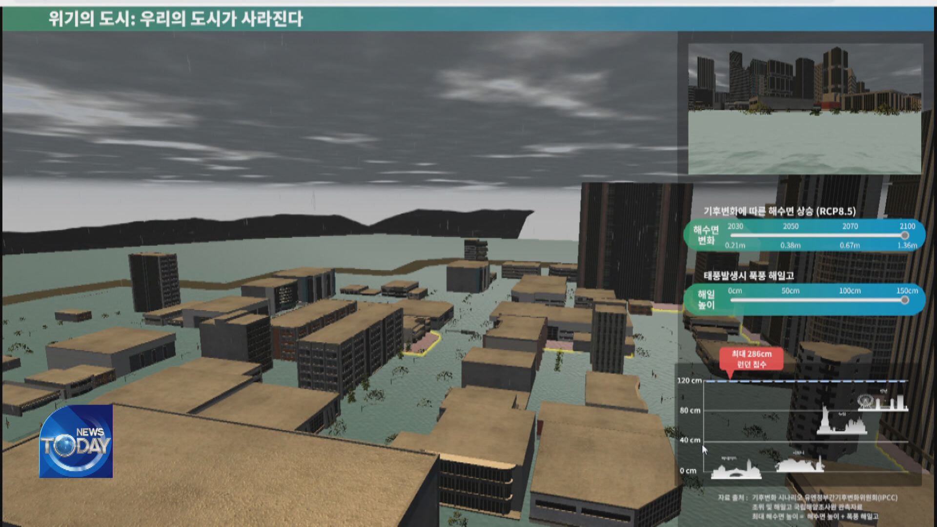
A virtual city with roads and structures built among high-rise buildings. In 30 years time, what would happen if the sea level rises by 40 centimeters and high tidal waves are caused? Sea water gushes in to swallow up roads, key facilities and buildings. The higher the sea level rises, the deeper flooding runs. At ports, cranes are inundated and only the tops of containers are seen. Water threatens to reach a bridge that was built dozens of meters above the surface. A sea wall in the middle of the ocean disappears under water. These are virtual images of a big-data-based scenario that was first produced to prepare against coastal disasters caused by rapid climate change.
[Soundbite] Lee Cheol-yong(Korea Institute of Ocean Science & Technology) : "The data can be used for the leisure industry and private industrial facilities, which are directly affected by changes in sea level, to preemptively prepare for possible damage."
A total of 160 types of big data on climate change, coastal disasters and safety facilities have been disclosed. 24 public agencies, private businesses and academic institutions, including the Korea Institute of Ocean Science and Technology, participated to collect the related data. The goal of the project is to lead the marine data market and promote the growth of related industries. The disclosed information is open to the public.
[Soundbite] Ha Yong-joon(Official, ElecOcean) : "Basic materials for experts are difficult. So we have made them more accessible and comprehensible for general users."
The data will also be used for establishing a Korean-style coastal disaster response system for which a preliminary feasibility study is being conducted.
Sea levels are rapidly rising due to many factors including climate change. According to coastal data released by the government Monday, South Korea's sea level rose close to 10 centimeters over the past 33 years. Coastal information based on big-data gathered from experts has been released to forecast possible disasters that may hit due to such high sea levels, and how to adapt to such change.
[Pkg]
A virtual city with roads and structures built among high-rise buildings. In 30 years time, what would happen if the sea level rises by 40 centimeters and high tidal waves are caused? Sea water gushes in to swallow up roads, key facilities and buildings. The higher the sea level rises, the deeper flooding runs. At ports, cranes are inundated and only the tops of containers are seen. Water threatens to reach a bridge that was built dozens of meters above the surface. A sea wall in the middle of the ocean disappears under water. These are virtual images of a big-data-based scenario that was first produced to prepare against coastal disasters caused by rapid climate change.
[Soundbite] Lee Cheol-yong(Korea Institute of Ocean Science & Technology) : "The data can be used for the leisure industry and private industrial facilities, which are directly affected by changes in sea level, to preemptively prepare for possible damage."
A total of 160 types of big data on climate change, coastal disasters and safety facilities have been disclosed. 24 public agencies, private businesses and academic institutions, including the Korea Institute of Ocean Science and Technology, participated to collect the related data. The goal of the project is to lead the marine data market and promote the growth of related industries. The disclosed information is open to the public.
[Soundbite] Ha Yong-joon(Official, ElecOcean) : "Basic materials for experts are difficult. So we have made them more accessible and comprehensible for general users."
The data will also be used for establishing a Korean-style coastal disaster response system for which a preliminary feasibility study is being conducted.
■ 제보하기
▷ 카카오톡 : 'KBS제보' 검색, 채널 추가
▷ 전화 : 02-781-1234, 4444
▷ 이메일 : kbs1234@kbs.co.kr
▷ 유튜브, 네이버, 카카오에서도 KBS뉴스를 구독해주세요!
- DATA ON RISING SEA LEVEL RISKS REVEALED
-
- 입력 2022-12-19 14:57:15
- 수정2022-12-19 16:45:05
[Anchor Lead]
Sea levels are rapidly rising due to many factors including climate change. According to coastal data released by the government Monday, South Korea's sea level rose close to 10 centimeters over the past 33 years. Coastal information based on big-data gathered from experts has been released to forecast possible disasters that may hit due to such high sea levels, and how to adapt to such change.
[Pkg]
A virtual city with roads and structures built among high-rise buildings. In 30 years time, what would happen if the sea level rises by 40 centimeters and high tidal waves are caused? Sea water gushes in to swallow up roads, key facilities and buildings. The higher the sea level rises, the deeper flooding runs. At ports, cranes are inundated and only the tops of containers are seen. Water threatens to reach a bridge that was built dozens of meters above the surface. A sea wall in the middle of the ocean disappears under water. These are virtual images of a big-data-based scenario that was first produced to prepare against coastal disasters caused by rapid climate change.
[Soundbite] Lee Cheol-yong(Korea Institute of Ocean Science & Technology) : "The data can be used for the leisure industry and private industrial facilities, which are directly affected by changes in sea level, to preemptively prepare for possible damage."
A total of 160 types of big data on climate change, coastal disasters and safety facilities have been disclosed. 24 public agencies, private businesses and academic institutions, including the Korea Institute of Ocean Science and Technology, participated to collect the related data. The goal of the project is to lead the marine data market and promote the growth of related industries. The disclosed information is open to the public.
[Soundbite] Ha Yong-joon(Official, ElecOcean) : "Basic materials for experts are difficult. So we have made them more accessible and comprehensible for general users."
The data will also be used for establishing a Korean-style coastal disaster response system for which a preliminary feasibility study is being conducted.
이 기사가 좋으셨다면
-
좋아요
0
-
응원해요
0
-
후속 원해요
0
오늘의 핫 클릭
실시간 뜨거운 관심을 받고 있는 뉴스
헤드라인


이 기사에 대한 의견을 남겨주세요.