


[Exclusive] N. Korea expands tactical roads near military demarcation line
입력 2024.10.17 (23:49)
읽어주기 기능은 크롬기반의
브라우저에서만 사용하실 수 있습니다.
[Anchor]
North Korea, which blew up the inter-Korean connection road, has recently been captured in satellite images extending military tactical roads and constructing new outposts in various locations around the military demarcation line.
The fortification work near the ceasefire line is progressing at a rapid pace.
This is an exclusive report by reporter Yang Min-cheol.
[Report]
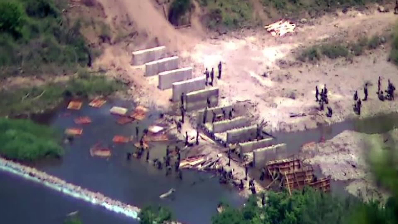
Hill 854 on the eastern front where fierce battles occurred between the South Korean military and the Chinese military at the end of the Korean War.
On the North's side of the demilitarized zone beyond the military demarcation line, the North Korean military tactical road runs almost parallel to the military demarcation line at a very close point.
However, satellite images taken on Oct. 13 show that this tactical road has been extended by about 1 km compared to August.
Such developments have been observed in several locations around the military demarcation line.
In the area of Pyonggang County, Gangwon Province, the North has begun constructing new tactical roads this year and has been steadily extending them, and recently, they have also been seen building outposts in various locations.
North Korea's tactical road near the most intense battleground of the Korean War, the Hwacheon area in Cheorwon County, Gangwon Province, has also been extended by more than 5 km in a straight line since mid-August.
[Jung Seong-hak/Director of Video Analysis Center, Korea Institute for Security Strategy: "It seems that the DPRK authorities are extending the tactical road as close as possible to the military demarcation line to advance the barbed wire."]
In the past two months, military activities of North Korea near the military demarcation line have been captured in a total of 11 locations in satellite images.
Experts believe that these measures appear to be an extension of the 'fortification' measures mentioned earlier by the North Korean military general staff and predict that they will expand further in the future.
[Yang Wook/Research Fellow, Asan Institute for Policy Studies: "(The extension of tactical roads) can be seen as making the connection between each outpost flexible, allowing troops to be freely deployed and equipment to be put in place at any time. It can be used for defense purposes but also for offense..."]
Since the end of last year, North Korea, which has brought up the notion of 'hostile two nations,' has recently raised concerns that it is accelerating the physical separation between the two Koreas.
This is KBS News, Yang Min-cheol.
North Korea, which blew up the inter-Korean connection road, has recently been captured in satellite images extending military tactical roads and constructing new outposts in various locations around the military demarcation line.
The fortification work near the ceasefire line is progressing at a rapid pace.
This is an exclusive report by reporter Yang Min-cheol.
[Report]
Hill 854 on the eastern front where fierce battles occurred between the South Korean military and the Chinese military at the end of the Korean War.
On the North's side of the demilitarized zone beyond the military demarcation line, the North Korean military tactical road runs almost parallel to the military demarcation line at a very close point.
However, satellite images taken on Oct. 13 show that this tactical road has been extended by about 1 km compared to August.
Such developments have been observed in several locations around the military demarcation line.
In the area of Pyonggang County, Gangwon Province, the North has begun constructing new tactical roads this year and has been steadily extending them, and recently, they have also been seen building outposts in various locations.
North Korea's tactical road near the most intense battleground of the Korean War, the Hwacheon area in Cheorwon County, Gangwon Province, has also been extended by more than 5 km in a straight line since mid-August.
[Jung Seong-hak/Director of Video Analysis Center, Korea Institute for Security Strategy: "It seems that the DPRK authorities are extending the tactical road as close as possible to the military demarcation line to advance the barbed wire."]
In the past two months, military activities of North Korea near the military demarcation line have been captured in a total of 11 locations in satellite images.
Experts believe that these measures appear to be an extension of the 'fortification' measures mentioned earlier by the North Korean military general staff and predict that they will expand further in the future.
[Yang Wook/Research Fellow, Asan Institute for Policy Studies: "(The extension of tactical roads) can be seen as making the connection between each outpost flexible, allowing troops to be freely deployed and equipment to be put in place at any time. It can be used for defense purposes but also for offense..."]
Since the end of last year, North Korea, which has brought up the notion of 'hostile two nations,' has recently raised concerns that it is accelerating the physical separation between the two Koreas.
This is KBS News, Yang Min-cheol.
■ 제보하기
▷ 카카오톡 : 'KBS제보' 검색, 채널 추가
▷ 전화 : 02-781-1234, 4444
▷ 이메일 : kbs1234@kbs.co.kr
▷ 유튜브, 네이버, 카카오에서도 KBS뉴스를 구독해주세요!
- [Exclusive] N. Korea expands tactical roads near military demarcation line
-
- 입력 2024-10-17 23:49:58
[Anchor]
North Korea, which blew up the inter-Korean connection road, has recently been captured in satellite images extending military tactical roads and constructing new outposts in various locations around the military demarcation line.
The fortification work near the ceasefire line is progressing at a rapid pace.
This is an exclusive report by reporter Yang Min-cheol.
[Report]
Hill 854 on the eastern front where fierce battles occurred between the South Korean military and the Chinese military at the end of the Korean War.
On the North's side of the demilitarized zone beyond the military demarcation line, the North Korean military tactical road runs almost parallel to the military demarcation line at a very close point.
However, satellite images taken on Oct. 13 show that this tactical road has been extended by about 1 km compared to August.
Such developments have been observed in several locations around the military demarcation line.
In the area of Pyonggang County, Gangwon Province, the North has begun constructing new tactical roads this year and has been steadily extending them, and recently, they have also been seen building outposts in various locations.
North Korea's tactical road near the most intense battleground of the Korean War, the Hwacheon area in Cheorwon County, Gangwon Province, has also been extended by more than 5 km in a straight line since mid-August.
[Jung Seong-hak/Director of Video Analysis Center, Korea Institute for Security Strategy: "It seems that the DPRK authorities are extending the tactical road as close as possible to the military demarcation line to advance the barbed wire."]
In the past two months, military activities of North Korea near the military demarcation line have been captured in a total of 11 locations in satellite images.
Experts believe that these measures appear to be an extension of the 'fortification' measures mentioned earlier by the North Korean military general staff and predict that they will expand further in the future.
[Yang Wook/Research Fellow, Asan Institute for Policy Studies: "(The extension of tactical roads) can be seen as making the connection between each outpost flexible, allowing troops to be freely deployed and equipment to be put in place at any time. It can be used for defense purposes but also for offense..."]
Since the end of last year, North Korea, which has brought up the notion of 'hostile two nations,' has recently raised concerns that it is accelerating the physical separation between the two Koreas.
This is KBS News, Yang Min-cheol.

이 기사가 좋으셨다면
-
좋아요
0
-
응원해요
0
-
후속 원해요
0
오늘의 핫 클릭
실시간 뜨거운 관심을 받고 있는 뉴스
헤드라인


이 기사에 대한 의견을 남겨주세요.