


Satellite images confirm North Korea’s installation of ‘anti-tank pits’ on site of recently blown-up inter-country roads
입력 2024.11.04 (23:52)
읽어주기 기능은 크롬기반의
브라우저에서만 사용하실 수 있습니다.
[Anchor]
The DPRK is also continuing its efforts to sever inter-Korean relations.
They have dug trenches to block the movement of tanks at the sites where the Gyeongui Line, Donghae Line, and inter-Korean roads were blown up.
Our military has assessed that this is merely a show of force with no practical utility.
Reporter Yang Min-cheol reports.
[Report]
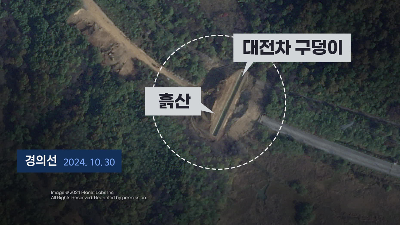
On the 15th of October, the DPRK blew up the connecting road between the Gyeongui Line and Donghae Line.
Since then, the DPRK has been constructing trenches for days to block tank movements in this area.
Photos released by the Joint Chiefs of Staff show a large anti-tank trench measuring 120 meters in length, 10 meters in width, and about 3 meters in depth in the Gyeongui Line area.
Behind it, a dirt mound measuring 45 meters in width and 11 meters in height has formed.
Satellite images also capture construction activities to have started from the 17th of October, after the road was blown up.
By the 30th of October, the anti-tank trench and dirt mound had taken shape.
On the Donghae Line, an anti-tank trench measuring 160 meters in length, 10 meters in width, and 5 meters in depth has also been created.
Behind it, a dirt mound measuring 50 meters in width and 5 meters in height has formed as well.
Satellite images show that after the road was blown up, a rectangular area was first shaped into a trench, followed by the accumulation of the dirt mound.
Notably, on the 1st (of Nov.), after the construction was completed on the Donghae Line, our military surveillance equipment captured DPRK soldiers planting a flag on the dirt mound and taking photos before quickly withdrawing.
The Joint Chiefs of Staff stated that this construction has no military utility from the DPRK's perspective and is merely a 'show of force' indicating that they have completed measures to block inter-Korean interactions.
[Lee Sung-jun/Director of Public Affairs, Joint Chiefs of Staff: "The DPRK can quickly fill the anti-tank trench with the dirt mound and create an invasion route, so our military is closely monitoring the area."]
Previously, the DPRK declared 'fortification' in this area, emphasizing the 'two nations' division, and is expected to continue the severing of the two countries for various purposes including preventing defection.
This is KBS News, Yang Min-cheol.
The DPRK is also continuing its efforts to sever inter-Korean relations.
They have dug trenches to block the movement of tanks at the sites where the Gyeongui Line, Donghae Line, and inter-Korean roads were blown up.
Our military has assessed that this is merely a show of force with no practical utility.
Reporter Yang Min-cheol reports.
[Report]
On the 15th of October, the DPRK blew up the connecting road between the Gyeongui Line and Donghae Line.
Since then, the DPRK has been constructing trenches for days to block tank movements in this area.
Photos released by the Joint Chiefs of Staff show a large anti-tank trench measuring 120 meters in length, 10 meters in width, and about 3 meters in depth in the Gyeongui Line area.
Behind it, a dirt mound measuring 45 meters in width and 11 meters in height has formed.
Satellite images also capture construction activities to have started from the 17th of October, after the road was blown up.
By the 30th of October, the anti-tank trench and dirt mound had taken shape.
On the Donghae Line, an anti-tank trench measuring 160 meters in length, 10 meters in width, and 5 meters in depth has also been created.
Behind it, a dirt mound measuring 50 meters in width and 5 meters in height has formed as well.
Satellite images show that after the road was blown up, a rectangular area was first shaped into a trench, followed by the accumulation of the dirt mound.
Notably, on the 1st (of Nov.), after the construction was completed on the Donghae Line, our military surveillance equipment captured DPRK soldiers planting a flag on the dirt mound and taking photos before quickly withdrawing.
The Joint Chiefs of Staff stated that this construction has no military utility from the DPRK's perspective and is merely a 'show of force' indicating that they have completed measures to block inter-Korean interactions.
[Lee Sung-jun/Director of Public Affairs, Joint Chiefs of Staff: "The DPRK can quickly fill the anti-tank trench with the dirt mound and create an invasion route, so our military is closely monitoring the area."]
Previously, the DPRK declared 'fortification' in this area, emphasizing the 'two nations' division, and is expected to continue the severing of the two countries for various purposes including preventing defection.
This is KBS News, Yang Min-cheol.
■ 제보하기
▷ 카카오톡 : 'KBS제보' 검색, 채널 추가
▷ 전화 : 02-781-1234, 4444
▷ 이메일 : kbs1234@kbs.co.kr
▷ 유튜브, 네이버, 카카오에서도 KBS뉴스를 구독해주세요!
- Satellite images confirm North Korea’s installation of ‘anti-tank pits’ on site of recently blown-up inter-country roads
-
- 입력 2024-11-04 23:52:28
[Anchor]
The DPRK is also continuing its efforts to sever inter-Korean relations.
They have dug trenches to block the movement of tanks at the sites where the Gyeongui Line, Donghae Line, and inter-Korean roads were blown up.
Our military has assessed that this is merely a show of force with no practical utility.
Reporter Yang Min-cheol reports.
[Report]
On the 15th of October, the DPRK blew up the connecting road between the Gyeongui Line and Donghae Line.
Since then, the DPRK has been constructing trenches for days to block tank movements in this area.
Photos released by the Joint Chiefs of Staff show a large anti-tank trench measuring 120 meters in length, 10 meters in width, and about 3 meters in depth in the Gyeongui Line area.
Behind it, a dirt mound measuring 45 meters in width and 11 meters in height has formed.
Satellite images also capture construction activities to have started from the 17th of October, after the road was blown up.
By the 30th of October, the anti-tank trench and dirt mound had taken shape.
On the Donghae Line, an anti-tank trench measuring 160 meters in length, 10 meters in width, and 5 meters in depth has also been created.
Behind it, a dirt mound measuring 50 meters in width and 5 meters in height has formed as well.
Satellite images show that after the road was blown up, a rectangular area was first shaped into a trench, followed by the accumulation of the dirt mound.
Notably, on the 1st (of Nov.), after the construction was completed on the Donghae Line, our military surveillance equipment captured DPRK soldiers planting a flag on the dirt mound and taking photos before quickly withdrawing.
The Joint Chiefs of Staff stated that this construction has no military utility from the DPRK's perspective and is merely a 'show of force' indicating that they have completed measures to block inter-Korean interactions.
[Lee Sung-jun/Director of Public Affairs, Joint Chiefs of Staff: "The DPRK can quickly fill the anti-tank trench with the dirt mound and create an invasion route, so our military is closely monitoring the area."]
Previously, the DPRK declared 'fortification' in this area, emphasizing the 'two nations' division, and is expected to continue the severing of the two countries for various purposes including preventing defection.
This is KBS News, Yang Min-cheol.

이 기사가 좋으셨다면
-
좋아요
0
-
응원해요
0
-
후속 원해요
0
오늘의 핫 클릭
실시간 뜨거운 관심을 받고 있는 뉴스
헤드라인


![[단독] 김민석 총리, 취임 첫 일정으로 ‘송미령 반대’ 농민단체 농성장 방문](/data/news/2025/07/03/20250703_YUTdgQ.png)
![[단독] ‘스테로이드’부터 ‘임신중지약’까지…해외 의약품 불법 유통 11만 건](/data/news/2025/07/03/20250703_qpUU1y.png)

이 기사에 대한 의견을 남겨주세요.