


Bitter cold follows heavy snowfall in central regions
입력 2024.11.29 (23:46)
읽어주기 기능은 크롬기반의
브라우저에서만 사용하실 수 있습니다.
[Anchor]
As the heavy snowfall subsides, bitter cold has arrived.
This morning (11.29), temperatures in the central inland areas dropped to around minus 15 degrees.
Tomorrow morning (11.30), which is a Saturday, will be just as cold as today.
Meteorologist Shin Bang-sil reports.
[Report]
Strong winds are sweeping across the peak of Daegwallyeong, shaking the camera.
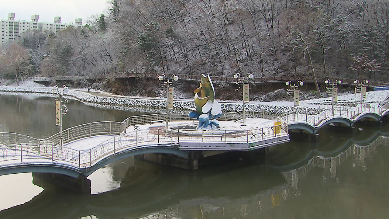
As the heavy snowfall subsided, harsh winter cold intensified, with the lowest temperature in Anheung, Gangwon Province, dropping to minus 16.3 degrees this morning.
Daegwallyeong recorded minus 11 degrees, and Seoul saw minus 3.4 degrees, marking the coldest temperatures of this autumn season, which are about 5 degrees lower than the average.
Tomorrow morning, Daegwallyeong will be minus 6 degrees, and Seoul will be minus 1 degree, continuing the sub-zero temperatures.
[Kim Dong-soo/Meteorological Administration Forecast Analyst: "With the cold air that has already affected the area still present, temperatures will drop overnight, and morning temperatures will be below 0 degrees, especially in the inland areas during the weekend."]
Temperatures will return to average levels starting tomorrow afternoon, and on Sunday (12.1) and next Monday, temperatures will rise significantly.
However, next Tuesday, another brief cold snap will hit, leading to significant temperature fluctuations.
Snow will continue in southern Gyeonggi, Chungcheong, and various southern regions until tonight.
The expected snowfall is 1 to 3 cm in eastern Jeonbuk, and around 1 cm in the southern inland of Gyeonggi, Chungcheong, and Yeongnam inland.
Although this amount is not much compared to the snow that has already fallen, precautions should be taken to prevent damage to facilities as a lot of snow has already accumulated.
Low-lying roads and alleyways can turn into icy paths due to the low temperatures, so caution is advised for safety.
The west coast of Chungnam and the Honam coast will experience very strong winds of around 20 m/s until tonight, and Jeju Island will see similar winds until tomorrow afternoon.
This is KBS News, Shin Bang-sil.
As the heavy snowfall subsides, bitter cold has arrived.
This morning (11.29), temperatures in the central inland areas dropped to around minus 15 degrees.
Tomorrow morning (11.30), which is a Saturday, will be just as cold as today.
Meteorologist Shin Bang-sil reports.
[Report]
Strong winds are sweeping across the peak of Daegwallyeong, shaking the camera.
As the heavy snowfall subsided, harsh winter cold intensified, with the lowest temperature in Anheung, Gangwon Province, dropping to minus 16.3 degrees this morning.
Daegwallyeong recorded minus 11 degrees, and Seoul saw minus 3.4 degrees, marking the coldest temperatures of this autumn season, which are about 5 degrees lower than the average.
Tomorrow morning, Daegwallyeong will be minus 6 degrees, and Seoul will be minus 1 degree, continuing the sub-zero temperatures.
[Kim Dong-soo/Meteorological Administration Forecast Analyst: "With the cold air that has already affected the area still present, temperatures will drop overnight, and morning temperatures will be below 0 degrees, especially in the inland areas during the weekend."]
Temperatures will return to average levels starting tomorrow afternoon, and on Sunday (12.1) and next Monday, temperatures will rise significantly.
However, next Tuesday, another brief cold snap will hit, leading to significant temperature fluctuations.
Snow will continue in southern Gyeonggi, Chungcheong, and various southern regions until tonight.
The expected snowfall is 1 to 3 cm in eastern Jeonbuk, and around 1 cm in the southern inland of Gyeonggi, Chungcheong, and Yeongnam inland.
Although this amount is not much compared to the snow that has already fallen, precautions should be taken to prevent damage to facilities as a lot of snow has already accumulated.
Low-lying roads and alleyways can turn into icy paths due to the low temperatures, so caution is advised for safety.
The west coast of Chungnam and the Honam coast will experience very strong winds of around 20 m/s until tonight, and Jeju Island will see similar winds until tomorrow afternoon.
This is KBS News, Shin Bang-sil.
■ 제보하기
▷ 카카오톡 : 'KBS제보' 검색, 채널 추가
▷ 전화 : 02-781-1234, 4444
▷ 이메일 : kbs1234@kbs.co.kr
▷ 유튜브, 네이버, 카카오에서도 KBS뉴스를 구독해주세요!
- Bitter cold follows heavy snowfall in central regions
-
- 입력 2024-11-29 23:46:17
[Anchor]
As the heavy snowfall subsides, bitter cold has arrived.
This morning (11.29), temperatures in the central inland areas dropped to around minus 15 degrees.
Tomorrow morning (11.30), which is a Saturday, will be just as cold as today.
Meteorologist Shin Bang-sil reports.
[Report]
Strong winds are sweeping across the peak of Daegwallyeong, shaking the camera.
As the heavy snowfall subsided, harsh winter cold intensified, with the lowest temperature in Anheung, Gangwon Province, dropping to minus 16.3 degrees this morning.
Daegwallyeong recorded minus 11 degrees, and Seoul saw minus 3.4 degrees, marking the coldest temperatures of this autumn season, which are about 5 degrees lower than the average.
Tomorrow morning, Daegwallyeong will be minus 6 degrees, and Seoul will be minus 1 degree, continuing the sub-zero temperatures.
[Kim Dong-soo/Meteorological Administration Forecast Analyst: "With the cold air that has already affected the area still present, temperatures will drop overnight, and morning temperatures will be below 0 degrees, especially in the inland areas during the weekend."]
Temperatures will return to average levels starting tomorrow afternoon, and on Sunday (12.1) and next Monday, temperatures will rise significantly.
However, next Tuesday, another brief cold snap will hit, leading to significant temperature fluctuations.
Snow will continue in southern Gyeonggi, Chungcheong, and various southern regions until tonight.
The expected snowfall is 1 to 3 cm in eastern Jeonbuk, and around 1 cm in the southern inland of Gyeonggi, Chungcheong, and Yeongnam inland.
Although this amount is not much compared to the snow that has already fallen, precautions should be taken to prevent damage to facilities as a lot of snow has already accumulated.
Low-lying roads and alleyways can turn into icy paths due to the low temperatures, so caution is advised for safety.
The west coast of Chungnam and the Honam coast will experience very strong winds of around 20 m/s until tonight, and Jeju Island will see similar winds until tomorrow afternoon.
This is KBS News, Shin Bang-sil.
-
-

신방실 기자 weezer@kbs.co.kr
신방실 기자의 기사 모음
-
이 기사가 좋으셨다면
-
좋아요
0
-
응원해요
0
-
후속 원해요
0
오늘의 핫 클릭
실시간 뜨거운 관심을 받고 있는 뉴스
헤드라인

![[단독] 김건희 특검, ‘공천 개입’ 관련 김영선 전 의원 소환 통보…일정 조율 중](/data/news/2025/07/16/20250716_p7hDHF.jpg)


이 기사에 대한 의견을 남겨주세요.