


Bad levels of find dust forecasted before coldest wave of this winter to hit on Thur.
입력 2025.01.05 (23:38)
읽어주기 기능은 크롬기반의
브라우저에서만 사용하실 수 있습니다.
[Anchor]
Today (Dec. 5) was the solar term of Minor Cold, bringing heavy snow in the metropolitan area and the western part of Gangwon Province.
Another round of snow is expected overnight, and after the snow stops tomorrow (Dec. 6), fine dust will follow, and a severe cold wave is predicted for the day after tomorrow (Dec. 7).
The weekly weather forecast will be delivered by meteorological expert Lee Jeong-hoon.
[Report]
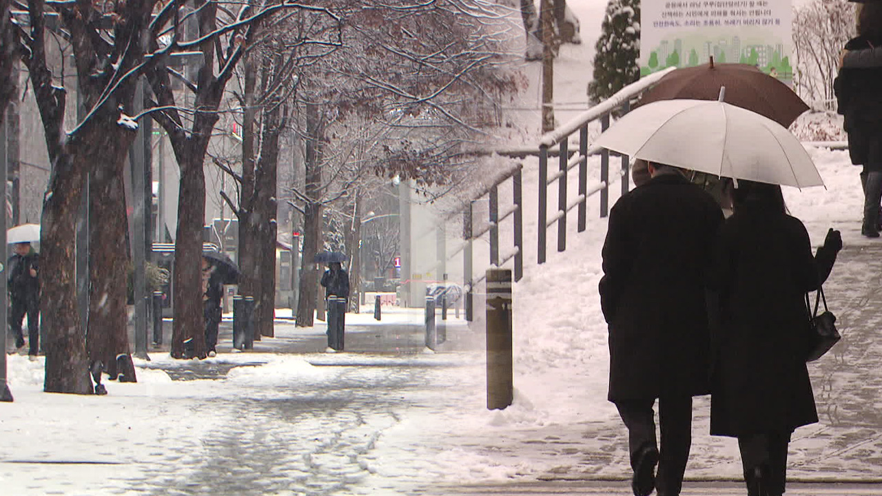
In the streets of Seoul, heavy snow has been falling since morning, and people are carefully making their way over the thickly piled snow.
Today, 6.4 cm of snow has accumulated in Seoul, while around 10 cm has fallen in the northern regions of Gyeonggi and Gangwon.
Until tomorrow morning, an additional 1 to 5 cm of snow is expected in the central inland and northern Gyeongsangbuk-do area, with about 1 cm more in Seoul and most other areas.
After the snow clouds pass, the unwelcomed fine dust will arrive.
This afternoon, the concentration of fine dust levels in the five islands of the West Sea has risen to 'very bad', and tomorrow morning, 'very bad' levels are expected in the central region, Honam, and Jeju.
The fine dust is expected to dissipate the day after tomorrow as cold winds move in.
The cold air looks black at 5 km above ground, reaching -40 degrees Celsius. It is gradually pushing southward and is predicted to reach North Korea by Wednesday.
[Yoon Ik-sang/Meteorological Administration Forecaster: "The cold upper-level low pressure over the northern part of the Korean Peninsula is stagnating due to the high pressure in the east, causing the cold air from the north to continuously flow into our country, prolonging the cold."]
Morning temperatures in Seoul are expected to drop further, with the coldest wave of this winter predicted to reach -11 degrees Celsius on Thursday and Friday.
As the cold air passes over the West Sea, it is expected to create snow clouds.
Due to the influence of these snow clouds, the Meteorological Administration has forecast that very heavy snow will fall in Chungcheong, Honam, and Jeju from Tuesday to Friday.
This is KBS News, Lee Jeong-hoon.
Today (Dec. 5) was the solar term of Minor Cold, bringing heavy snow in the metropolitan area and the western part of Gangwon Province.
Another round of snow is expected overnight, and after the snow stops tomorrow (Dec. 6), fine dust will follow, and a severe cold wave is predicted for the day after tomorrow (Dec. 7).
The weekly weather forecast will be delivered by meteorological expert Lee Jeong-hoon.
[Report]
In the streets of Seoul, heavy snow has been falling since morning, and people are carefully making their way over the thickly piled snow.
Today, 6.4 cm of snow has accumulated in Seoul, while around 10 cm has fallen in the northern regions of Gyeonggi and Gangwon.
Until tomorrow morning, an additional 1 to 5 cm of snow is expected in the central inland and northern Gyeongsangbuk-do area, with about 1 cm more in Seoul and most other areas.
After the snow clouds pass, the unwelcomed fine dust will arrive.
This afternoon, the concentration of fine dust levels in the five islands of the West Sea has risen to 'very bad', and tomorrow morning, 'very bad' levels are expected in the central region, Honam, and Jeju.
The fine dust is expected to dissipate the day after tomorrow as cold winds move in.
The cold air looks black at 5 km above ground, reaching -40 degrees Celsius. It is gradually pushing southward and is predicted to reach North Korea by Wednesday.
[Yoon Ik-sang/Meteorological Administration Forecaster: "The cold upper-level low pressure over the northern part of the Korean Peninsula is stagnating due to the high pressure in the east, causing the cold air from the north to continuously flow into our country, prolonging the cold."]
Morning temperatures in Seoul are expected to drop further, with the coldest wave of this winter predicted to reach -11 degrees Celsius on Thursday and Friday.
As the cold air passes over the West Sea, it is expected to create snow clouds.
Due to the influence of these snow clouds, the Meteorological Administration has forecast that very heavy snow will fall in Chungcheong, Honam, and Jeju from Tuesday to Friday.
This is KBS News, Lee Jeong-hoon.
■ 제보하기
▷ 카카오톡 : 'KBS제보' 검색, 채널 추가
▷ 전화 : 02-781-1234, 4444
▷ 이메일 : kbs1234@kbs.co.kr
▷ 유튜브, 네이버, 카카오에서도 KBS뉴스를 구독해주세요!
- Bad levels of find dust forecasted before coldest wave of this winter to hit on Thur.
-
- 입력 2025-01-05 23:38:15
[Anchor]
Today (Dec. 5) was the solar term of Minor Cold, bringing heavy snow in the metropolitan area and the western part of Gangwon Province.
Another round of snow is expected overnight, and after the snow stops tomorrow (Dec. 6), fine dust will follow, and a severe cold wave is predicted for the day after tomorrow (Dec. 7).
The weekly weather forecast will be delivered by meteorological expert Lee Jeong-hoon.
[Report]
In the streets of Seoul, heavy snow has been falling since morning, and people are carefully making their way over the thickly piled snow.
Today, 6.4 cm of snow has accumulated in Seoul, while around 10 cm has fallen in the northern regions of Gyeonggi and Gangwon.
Until tomorrow morning, an additional 1 to 5 cm of snow is expected in the central inland and northern Gyeongsangbuk-do area, with about 1 cm more in Seoul and most other areas.
After the snow clouds pass, the unwelcomed fine dust will arrive.
This afternoon, the concentration of fine dust levels in the five islands of the West Sea has risen to 'very bad', and tomorrow morning, 'very bad' levels are expected in the central region, Honam, and Jeju.
The fine dust is expected to dissipate the day after tomorrow as cold winds move in.
The cold air looks black at 5 km above ground, reaching -40 degrees Celsius. It is gradually pushing southward and is predicted to reach North Korea by Wednesday.
[Yoon Ik-sang/Meteorological Administration Forecaster: "The cold upper-level low pressure over the northern part of the Korean Peninsula is stagnating due to the high pressure in the east, causing the cold air from the north to continuously flow into our country, prolonging the cold."]
Morning temperatures in Seoul are expected to drop further, with the coldest wave of this winter predicted to reach -11 degrees Celsius on Thursday and Friday.
As the cold air passes over the West Sea, it is expected to create snow clouds.
Due to the influence of these snow clouds, the Meteorological Administration has forecast that very heavy snow will fall in Chungcheong, Honam, and Jeju from Tuesday to Friday.
This is KBS News, Lee Jeong-hoon.
-
-

이정훈 기자 skyclear@kbs.co.kr
이정훈 기자의 기사 모음
-
이 기사가 좋으셨다면
-
좋아요
0
-
응원해요
0
-
후속 원해요
0
오늘의 핫 클릭
실시간 뜨거운 관심을 받고 있는 뉴스
헤드라인
![[단독] “윤석열·김용현 등 공모해 군사상 이익 해쳐”<br>…외환죄 대신 일반이적죄 적용](/data/layer/904/2025/07/20250714_3VTJV3.jpg)


이 기사에 대한 의견을 남겨주세요.