


[Anchor]
Yes, the situation is not safe until tomorrow morning (8.14).
Heavy rain and extreme downpours are expected overnight in the metropolitan area and central regions.
Let's connect to the disaster broadcasting studio.
Reporter Shin Bang-sil! First, let's take a look at the areas where it is currently raining heavily and where it will rain heavily in the future.
[Reporter]
Looking at the radar images, a thin band of rain clouds appearing red over the West Sea is pushing inland.
The strongly compressed rain clouds are moving further south, bringing about 30mm of rain per hour to northern Chungcheongnam-do and southern Gyeonggi-do.
The rain will become even heavier overnight.
In the metropolitan area, strong rain will fall at rates of up to 70mm per hour until dawn tomorrow.
In Gangwon Yeongseo and northern Chungcheong, rain of 30 to 50mm per hour is also expected.
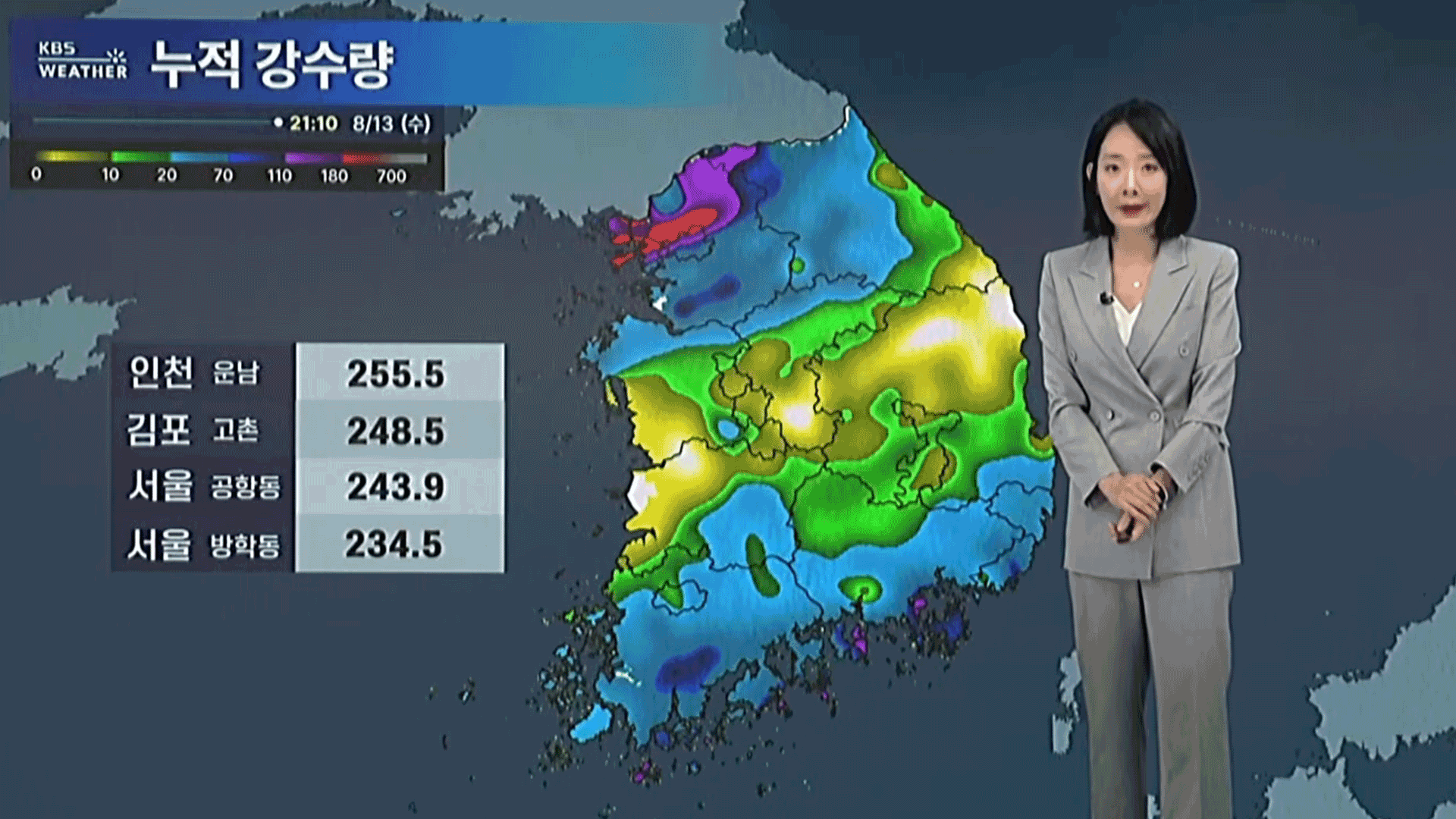
As you can see, the accumulated rainfall today has exceeded 200mm in various places in the metropolitan area.
With no time to recover from the damage caused by the heavy rain, strong rain is expected again tonight, so we must remain vigilant throughout the night.
[Anchor]
Today (8.13), there were places where nearly 150mm fell in one hour.
Why is the heavy rain pouring down like this?
[Reporter]
This is the radar image from this morning.
A very strong rain cloud band, appearing black, has moved into the metropolitan area.
The hourly rainfall peaked at 149.2mm in Ongjin-gun, Incheon, with over 100mm recorded in Seoul, Goyang, and Gimpo.
In particular, the heavy rain in Ongjin-gun today has been recorded as the strongest rain of the year, surpassing the rain that fell in Hampyeong, Jeollanam-do, ten days ago.
The cause of the extreme downpour is due to a stationary front accompanied by a low-pressure system moving northward into the central region.
Hot moisture from Typhoon No. 11 'Podul' near Taiwan has also surged in, explosively growing the rain clouds along the stationary front.
As the stationary front moves further north overnight, an additional 200mm of rain is forecasted for the metropolitan area and over 150mm for Gangwon Yeongseo and northern Chungcheong by tomorrow.
The critical period for this rain is until dawn tomorrow.
With heavy rain already having fallen and an additional 200mm forecasted, thorough preparations are necessary to prevent landslides and flooding.
This has been a report from the disaster broadcasting studio.
Yes, the situation is not safe until tomorrow morning (8.14).
Heavy rain and extreme downpours are expected overnight in the metropolitan area and central regions.
Let's connect to the disaster broadcasting studio.
Reporter Shin Bang-sil! First, let's take a look at the areas where it is currently raining heavily and where it will rain heavily in the future.
[Reporter]
Looking at the radar images, a thin band of rain clouds appearing red over the West Sea is pushing inland.
The strongly compressed rain clouds are moving further south, bringing about 30mm of rain per hour to northern Chungcheongnam-do and southern Gyeonggi-do.
The rain will become even heavier overnight.
In the metropolitan area, strong rain will fall at rates of up to 70mm per hour until dawn tomorrow.
In Gangwon Yeongseo and northern Chungcheong, rain of 30 to 50mm per hour is also expected.
As you can see, the accumulated rainfall today has exceeded 200mm in various places in the metropolitan area.
With no time to recover from the damage caused by the heavy rain, strong rain is expected again tonight, so we must remain vigilant throughout the night.
[Anchor]
Today (8.13), there were places where nearly 150mm fell in one hour.
Why is the heavy rain pouring down like this?
[Reporter]
This is the radar image from this morning.
A very strong rain cloud band, appearing black, has moved into the metropolitan area.
The hourly rainfall peaked at 149.2mm in Ongjin-gun, Incheon, with over 100mm recorded in Seoul, Goyang, and Gimpo.
In particular, the heavy rain in Ongjin-gun today has been recorded as the strongest rain of the year, surpassing the rain that fell in Hampyeong, Jeollanam-do, ten days ago.
The cause of the extreme downpour is due to a stationary front accompanied by a low-pressure system moving northward into the central region.
Hot moisture from Typhoon No. 11 'Podul' near Taiwan has also surged in, explosively growing the rain clouds along the stationary front.
As the stationary front moves further north overnight, an additional 200mm of rain is forecasted for the metropolitan area and over 150mm for Gangwon Yeongseo and northern Chungcheong by tomorrow.
The critical period for this rain is until dawn tomorrow.
With heavy rain already having fallen and an additional 200mm forecasted, thorough preparations are necessary to prevent landslides and flooding.
This has been a report from the disaster broadcasting studio.
■ 제보하기
▷ 카카오톡 : 'KBS제보' 검색, 채널 추가
▷ 전화 : 02-781-1234, 4444
▷ 이메일 : kbs1234@kbs.co.kr
▷ 유튜브, 네이버, 카카오에서도 KBS뉴스를 구독해주세요!
- Heavy rain to peak
-
- 입력 2025-08-13 23:43:56
[Anchor]
Yes, the situation is not safe until tomorrow morning (8.14).
Heavy rain and extreme downpours are expected overnight in the metropolitan area and central regions.
Let's connect to the disaster broadcasting studio.
Reporter Shin Bang-sil! First, let's take a look at the areas where it is currently raining heavily and where it will rain heavily in the future.
[Reporter]
Looking at the radar images, a thin band of rain clouds appearing red over the West Sea is pushing inland.
The strongly compressed rain clouds are moving further south, bringing about 30mm of rain per hour to northern Chungcheongnam-do and southern Gyeonggi-do.
The rain will become even heavier overnight.
In the metropolitan area, strong rain will fall at rates of up to 70mm per hour until dawn tomorrow.
In Gangwon Yeongseo and northern Chungcheong, rain of 30 to 50mm per hour is also expected.
As you can see, the accumulated rainfall today has exceeded 200mm in various places in the metropolitan area.
With no time to recover from the damage caused by the heavy rain, strong rain is expected again tonight, so we must remain vigilant throughout the night.
[Anchor]
Today (8.13), there were places where nearly 150mm fell in one hour.
Why is the heavy rain pouring down like this?
[Reporter]
This is the radar image from this morning.
A very strong rain cloud band, appearing black, has moved into the metropolitan area.
The hourly rainfall peaked at 149.2mm in Ongjin-gun, Incheon, with over 100mm recorded in Seoul, Goyang, and Gimpo.
In particular, the heavy rain in Ongjin-gun today has been recorded as the strongest rain of the year, surpassing the rain that fell in Hampyeong, Jeollanam-do, ten days ago.
The cause of the extreme downpour is due to a stationary front accompanied by a low-pressure system moving northward into the central region.
Hot moisture from Typhoon No. 11 'Podul' near Taiwan has also surged in, explosively growing the rain clouds along the stationary front.
As the stationary front moves further north overnight, an additional 200mm of rain is forecasted for the metropolitan area and over 150mm for Gangwon Yeongseo and northern Chungcheong by tomorrow.
The critical period for this rain is until dawn tomorrow.
With heavy rain already having fallen and an additional 200mm forecasted, thorough preparations are necessary to prevent landslides and flooding.
This has been a report from the disaster broadcasting studio.
-
-

신방실 기자 weezer@kbs.co.kr
신방실 기자의 기사 모음
-
이 기사가 좋으셨다면
-
좋아요
0
-
응원해요
0
-
후속 원해요
0
오늘의 핫 클릭
실시간 뜨거운 관심을 받고 있는 뉴스
헤드라인
![[속보] 이 대통령 “온실가스 감축 목표 달성 위해선 <br>전기요금 오를 수밖에”](/data/layer/904/2025/08/20250814_UfS9SE.jpg)

![[단독] 민주당, ‘김건희·내란 특검법’ 개정 추진…“수사 중 도피하면 공소시효 정지”](/data/layer/904/2025/08/20250814_2dd5Oj.jpg)


이 기사에 대한 의견을 남겨주세요.