


Dry East Coast at risk of wildfires
입력 2025.02.22 (23:07)
읽어주기 기능은 크롬기반의
브라우저에서만 사용하실 수 있습니다.
[Anchor]
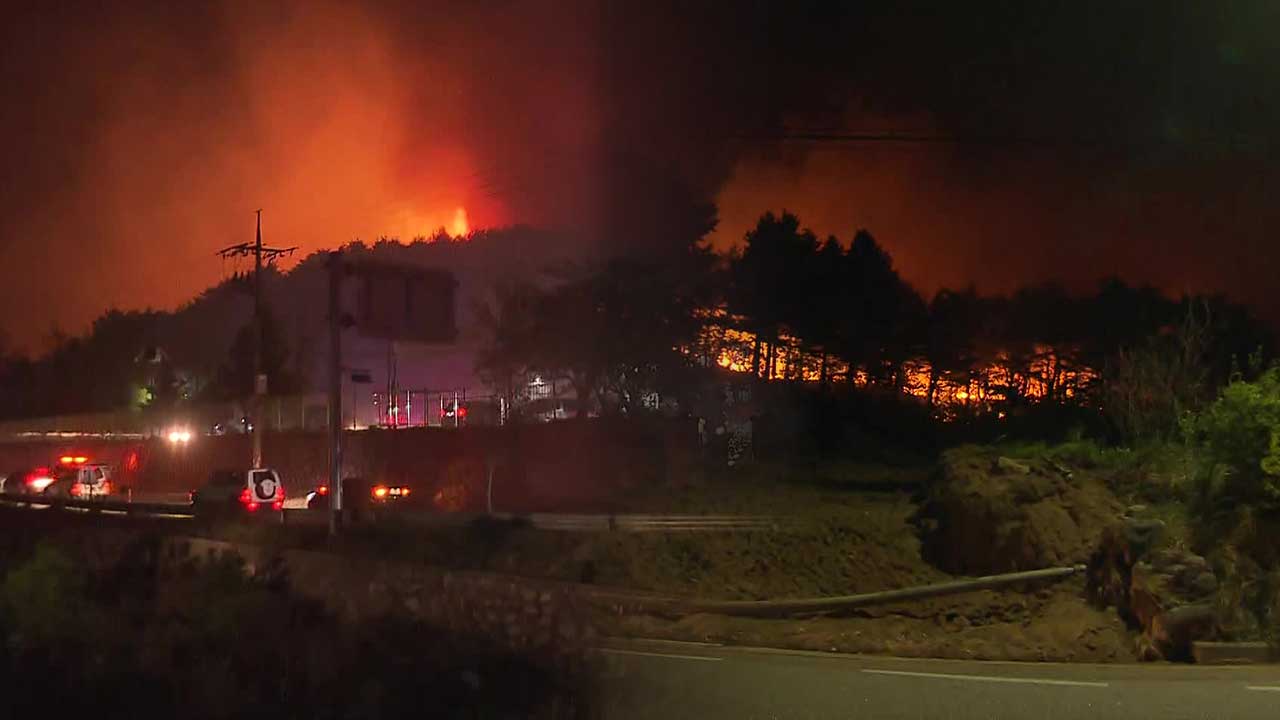
Currently, the East Coast is in a very dry state due to the unusually low precipitation this winter.
In particular, next week, the 'Yangganjipung' wind, which is cited as a cause of large wildfires, is expected to blow, making the risk of wildfires very high.
For the time being, we need to be cautious of even small sparks.
Our meteorological specialist Lee Se-heum reports.
[Report]
The 2005 Yangyang wildfire engulfed the thousand-year-old temple Naksansa.
The 2019 Goseong wildfire led to a national disaster declaration.
These large wildfires left behind record damage, and a common factor is that the spring 'Yangganjipung' wind fueled the flames.
It refers to the localized strong winds blowing between Yangyang and Ganseong on the East Coast from now until May, which are dangerously hot and dry.
It ignites large fires in conjunction with the dry season and is also called 'Hwafeng', or fire wind.
At the beginning of next week, clear and dry weather is forecasted along with the possibility of Yangganjipung blowing in the East Coast region.
[Yoon Ik-sang/Chief Forecaster, Korea Meteorological Administration: "From next Tuesday, a high pressure system will be located to the south and a low pressure system to the north, causing the westerly winds to strengthen rapidly as they cross the Taebaek Mountains, resulting in very strong winds with maximum gusts exceeding 28m/s, especially along the East Coast."]
Since December of last year, the winter precipitation on the East Coast has been less than one-tenth of last winter's amount.
This spring is particularly dangerous.
[Kwon Chun-geun/Researcher, National Institute of Forest Science: "With the dry weather advisory in effect, conditions are forming where small sparks can easily ignite, and if a strong wind advisory is also issued simultaneously, it could develop into a very dangerous situation...."]
Until next week, except for Jeju and the southern coast, there is no forecast of rain, so the risk of wildfires is expected to continue to rise.
Lee Se-heum, KBS News.
■ 제보하기
▷ 카카오톡 : 'KBS제보' 검색, 채널 추가
▷ 전화 : 02-781-1234, 4444
▷ 이메일 : kbs1234@kbs.co.kr
▷ 유튜브, 네이버, 카카오에서도 KBS뉴스를 구독해주세요!
- Dry East Coast at risk of wildfires
-
- 입력 2025-02-22 23:07:29
[Anchor]
Currently, the East Coast is in a very dry state due to the unusually low precipitation this winter.
In particular, next week, the 'Yangganjipung' wind, which is cited as a cause of large wildfires, is expected to blow, making the risk of wildfires very high.
For the time being, we need to be cautious of even small sparks.
Our meteorological specialist Lee Se-heum reports.
[Report]
The 2005 Yangyang wildfire engulfed the thousand-year-old temple Naksansa.
The 2019 Goseong wildfire led to a national disaster declaration.
These large wildfires left behind record damage, and a common factor is that the spring 'Yangganjipung' wind fueled the flames.
It refers to the localized strong winds blowing between Yangyang and Ganseong on the East Coast from now until May, which are dangerously hot and dry.
It ignites large fires in conjunction with the dry season and is also called 'Hwafeng', or fire wind.
At the beginning of next week, clear and dry weather is forecasted along with the possibility of Yangganjipung blowing in the East Coast region.
[Yoon Ik-sang/Chief Forecaster, Korea Meteorological Administration: "From next Tuesday, a high pressure system will be located to the south and a low pressure system to the north, causing the westerly winds to strengthen rapidly as they cross the Taebaek Mountains, resulting in very strong winds with maximum gusts exceeding 28m/s, especially along the East Coast."]
Since December of last year, the winter precipitation on the East Coast has been less than one-tenth of last winter's amount.
This spring is particularly dangerous.
[Kwon Chun-geun/Researcher, National Institute of Forest Science: "With the dry weather advisory in effect, conditions are forming where small sparks can easily ignite, and if a strong wind advisory is also issued simultaneously, it could develop into a very dangerous situation...."]
Until next week, except for Jeju and the southern coast, there is no forecast of rain, so the risk of wildfires is expected to continue to rise.
Lee Se-heum, KBS News.
-
-

이세흠 기자 hmm@kbs.co.kr
이세흠 기자의 기사 모음
-
이 기사가 좋으셨다면
-
좋아요
0
-
응원해요
0
-
후속 원해요
0
오늘의 핫 클릭
실시간 뜨거운 관심을 받고 있는 뉴스
헤드라인


많이 본 뉴스
-
각 플랫폼에서 최근 1시간 동안 많이 본 KBS 기사를 제공합니다.
-
각 플랫폼에서 최근 1시간 동안 많이 본 KBS 기사를 제공합니다.
-
각 플랫폼에서 최근 1시간 동안 많이 본 KBS 기사를 제공합니다.
이 기사에 대한 의견을 남겨주세요.