


[Anchor]
A 'braille map' has been created for the visually impaired to explore national parks.
After selecting less dangerous trails, braille has been added to the map, which is expected to expand the activity range for visually impaired individuals.
Reporter Lee Se-heum has the story.
[Report]
Through a flat dirt path, into the forest where the sound of a cool waterfall can be heard.
Mr. Yoo Yong-seop, who has severe visual impairment, set out on an exploration of Bukhansan Mountain with a friend.
[“It’s a bit bumpy, so I think I need to be careful.”]
[Yoo Yong-seop/Severe Visual Impairment: “(Isn’t it difficult to walk in the forest?) That’s right. It’s very difficult. There are many stones and uncomfortable spots, but this seems very comfortable here.”]
A survey conducted last year showed 'outdoor walking or hiking' to rank first in both activities the visually impaired participated in and wished to participate in.
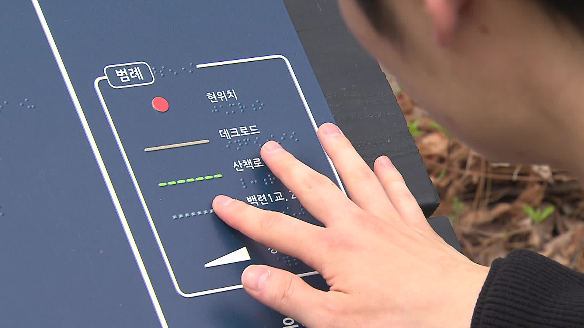
To assist visually impaired individuals in exploring national parks with activity assistants, the Korea National Park Service has created barrier-free trails and developed a 'braille map.'
The map prominently marks stairs and narrow paths, and uses larger text and bright colors for those with low vision.
[Kim Hyun-young/Principal Researcher, National Park Research Institute: “They need to read the braille and beb able to visualize the trail in their minds, so rather than including too much content, we took the suggestion that it would be better to focus on the necessary information.”]
Although the map is simplified, it significantly reduces the anxiety of visually impaired individuals as they visualize the trail in their minds.
[Yoo Yong-seop/Severe Visual Impairment: “If I can refer to the braille map beforehand, it might help a bit. I hope there are more of these. I have never been to Seoraksan. I think it would be good to research it through braille and then visit.”]
The Korea National Park Service plans to expand the braille maps created for eight national parks, including Bukhansan Mountain, to all 23 national parks by 2026.
KBS News, Lee Se-heum.
A 'braille map' has been created for the visually impaired to explore national parks.
After selecting less dangerous trails, braille has been added to the map, which is expected to expand the activity range for visually impaired individuals.
Reporter Lee Se-heum has the story.
[Report]
Through a flat dirt path, into the forest where the sound of a cool waterfall can be heard.
Mr. Yoo Yong-seop, who has severe visual impairment, set out on an exploration of Bukhansan Mountain with a friend.
[“It’s a bit bumpy, so I think I need to be careful.”]
[Yoo Yong-seop/Severe Visual Impairment: “(Isn’t it difficult to walk in the forest?) That’s right. It’s very difficult. There are many stones and uncomfortable spots, but this seems very comfortable here.”]
A survey conducted last year showed 'outdoor walking or hiking' to rank first in both activities the visually impaired participated in and wished to participate in.
To assist visually impaired individuals in exploring national parks with activity assistants, the Korea National Park Service has created barrier-free trails and developed a 'braille map.'
The map prominently marks stairs and narrow paths, and uses larger text and bright colors for those with low vision.
[Kim Hyun-young/Principal Researcher, National Park Research Institute: “They need to read the braille and beb able to visualize the trail in their minds, so rather than including too much content, we took the suggestion that it would be better to focus on the necessary information.”]
Although the map is simplified, it significantly reduces the anxiety of visually impaired individuals as they visualize the trail in their minds.
[Yoo Yong-seop/Severe Visual Impairment: “If I can refer to the braille map beforehand, it might help a bit. I hope there are more of these. I have never been to Seoraksan. I think it would be good to research it through braille and then visit.”]
The Korea National Park Service plans to expand the braille maps created for eight national parks, including Bukhansan Mountain, to all 23 national parks by 2026.
KBS News, Lee Se-heum.
■ 제보하기
▷ 카카오톡 : 'KBS제보' 검색, 채널 추가
▷ 전화 : 02-781-1234, 4444
▷ 이메일 : kbs1234@kbs.co.kr
▷ 유튜브, 네이버, 카카오에서도 KBS뉴스를 구독해주세요!
- National Park braille trail maps
-
- 입력 2025-04-28 02:03:06
[Anchor]
A 'braille map' has been created for the visually impaired to explore national parks.
After selecting less dangerous trails, braille has been added to the map, which is expected to expand the activity range for visually impaired individuals.
Reporter Lee Se-heum has the story.
[Report]
Through a flat dirt path, into the forest where the sound of a cool waterfall can be heard.
Mr. Yoo Yong-seop, who has severe visual impairment, set out on an exploration of Bukhansan Mountain with a friend.
[“It’s a bit bumpy, so I think I need to be careful.”]
[Yoo Yong-seop/Severe Visual Impairment: “(Isn’t it difficult to walk in the forest?) That’s right. It’s very difficult. There are many stones and uncomfortable spots, but this seems very comfortable here.”]
A survey conducted last year showed 'outdoor walking or hiking' to rank first in both activities the visually impaired participated in and wished to participate in.
To assist visually impaired individuals in exploring national parks with activity assistants, the Korea National Park Service has created barrier-free trails and developed a 'braille map.'
The map prominently marks stairs and narrow paths, and uses larger text and bright colors for those with low vision.
[Kim Hyun-young/Principal Researcher, National Park Research Institute: “They need to read the braille and beb able to visualize the trail in their minds, so rather than including too much content, we took the suggestion that it would be better to focus on the necessary information.”]
Although the map is simplified, it significantly reduces the anxiety of visually impaired individuals as they visualize the trail in their minds.
[Yoo Yong-seop/Severe Visual Impairment: “If I can refer to the braille map beforehand, it might help a bit. I hope there are more of these. I have never been to Seoraksan. I think it would be good to research it through braille and then visit.”]
The Korea National Park Service plans to expand the braille maps created for eight national parks, including Bukhansan Mountain, to all 23 national parks by 2026.
KBS News, Lee Se-heum.
-
-

이세흠 기자 hmm@kbs.co.kr
이세흠 기자의 기사 모음
-
이 기사가 좋으셨다면
-
좋아요
0
-
응원해요
0
-
후속 원해요
0
오늘의 핫 클릭
실시간 뜨거운 관심을 받고 있는 뉴스
헤드라인


이 기사에 대한 의견을 남겨주세요.