


[Anchor]
Now, let's connect to the disaster broadcasting studio to get more details on the heavy rain situation.
Reporter Shin Bang-sil, which areas are currently experiencing heavy rainfall?
[Reporter]
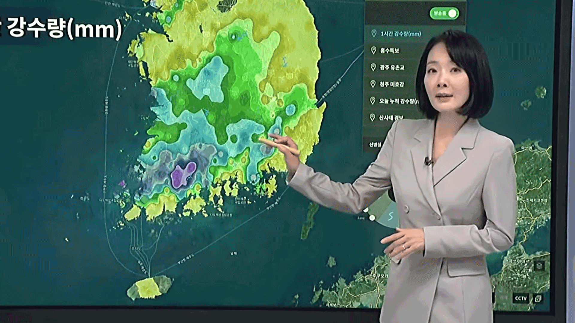
Let's take a look at the recent hourly rainfall distribution on the disaster status board.
A band of strong rain clouds is passing through the Jeonnam region, bringing heavy rain of around 60mm per hour.
Following the Chungnam region, the southern areas are also experiencing significant rainfall, causing river water levels to rise rapidly.
Flood warnings in red and orange are being expanded and intensified.
First, let's go to the Yeongsan River basin, where a flood warning is in effect.
At the Yuchon Bridge in Gwangju, the current water level is on a downward trend, but the river is surging violently.
Due to the risk of flooding in the Gwangjucheon Stream and other areas, evacuation orders have been issued for the northern and western districts of Gwangju.
Next, let's check the Geumgang River basin.
In Cheongju, the Miho River's water level has dropped below 8 meters, but a flood warning is still in effect.
You must not approach the riverbanks overnight.
[Anchor]
Additionally, landslides are a major concern.
What are the currently dangerous areas?
[Reporter]
Looking at the accumulated rainfall for today (July 17), areas in Chungnam such as Seosan and Hongseong, marked in red, as well as Jeonnam and Gyeongnam, have recorded around 400mm.
This is equivalent to one-third of the annual rainfall falling in just one day.
As the ground weakens, reports of landslides are coming in from various places.
Landslide warnings are in effect in areas marked in red, including Chungcheong, Jeonnam, and Yeongnam, while landslide advisories are in effect in the remaining orange areas.
A landslide warning is issued when the soil moisture content reaches 100%, indicating that the soil is saturated and cannot hold any more moisture, which means the risk of landslides is very high.
As damage from the heavy rain is expected to increase, the government has raised the Central Disaster and Safety Countermeasure Headquarters to Level 3.
This is the first time in two years that the Level 3 has been activated since the disaster situation caused by Typhoon Kanun in August 2023.
As of 6 PM today, the official tally of casualties reported by the headquarters is 4 dead and 1,382 evacuated.
This has been a report from the disaster broadcasting studio.
Now, let's connect to the disaster broadcasting studio to get more details on the heavy rain situation.
Reporter Shin Bang-sil, which areas are currently experiencing heavy rainfall?
[Reporter]
Let's take a look at the recent hourly rainfall distribution on the disaster status board.
A band of strong rain clouds is passing through the Jeonnam region, bringing heavy rain of around 60mm per hour.
Following the Chungnam region, the southern areas are also experiencing significant rainfall, causing river water levels to rise rapidly.
Flood warnings in red and orange are being expanded and intensified.
First, let's go to the Yeongsan River basin, where a flood warning is in effect.
At the Yuchon Bridge in Gwangju, the current water level is on a downward trend, but the river is surging violently.
Due to the risk of flooding in the Gwangjucheon Stream and other areas, evacuation orders have been issued for the northern and western districts of Gwangju.
Next, let's check the Geumgang River basin.
In Cheongju, the Miho River's water level has dropped below 8 meters, but a flood warning is still in effect.
You must not approach the riverbanks overnight.
[Anchor]
Additionally, landslides are a major concern.
What are the currently dangerous areas?
[Reporter]
Looking at the accumulated rainfall for today (July 17), areas in Chungnam such as Seosan and Hongseong, marked in red, as well as Jeonnam and Gyeongnam, have recorded around 400mm.
This is equivalent to one-third of the annual rainfall falling in just one day.
As the ground weakens, reports of landslides are coming in from various places.
Landslide warnings are in effect in areas marked in red, including Chungcheong, Jeonnam, and Yeongnam, while landslide advisories are in effect in the remaining orange areas.
A landslide warning is issued when the soil moisture content reaches 100%, indicating that the soil is saturated and cannot hold any more moisture, which means the risk of landslides is very high.
As damage from the heavy rain is expected to increase, the government has raised the Central Disaster and Safety Countermeasure Headquarters to Level 3.
This is the first time in two years that the Level 3 has been activated since the disaster situation caused by Typhoon Kanun in August 2023.
As of 6 PM today, the official tally of casualties reported by the headquarters is 4 dead and 1,382 evacuated.
This has been a report from the disaster broadcasting studio.
■ 제보하기
▷ 카카오톡 : 'KBS제보' 검색, 채널 추가
▷ 전화 : 02-781-1234, 4444
▷ 이메일 : kbs1234@kbs.co.kr
▷ 유튜브, 네이버, 카카오에서도 KBS뉴스를 구독해주세요!
- Latest on Disaster Board
-
- 입력 2025-07-18 00:40:32
[Anchor]
Now, let's connect to the disaster broadcasting studio to get more details on the heavy rain situation.
Reporter Shin Bang-sil, which areas are currently experiencing heavy rainfall?
[Reporter]
Let's take a look at the recent hourly rainfall distribution on the disaster status board.
A band of strong rain clouds is passing through the Jeonnam region, bringing heavy rain of around 60mm per hour.
Following the Chungnam region, the southern areas are also experiencing significant rainfall, causing river water levels to rise rapidly.
Flood warnings in red and orange are being expanded and intensified.
First, let's go to the Yeongsan River basin, where a flood warning is in effect.
At the Yuchon Bridge in Gwangju, the current water level is on a downward trend, but the river is surging violently.
Due to the risk of flooding in the Gwangjucheon Stream and other areas, evacuation orders have been issued for the northern and western districts of Gwangju.
Next, let's check the Geumgang River basin.
In Cheongju, the Miho River's water level has dropped below 8 meters, but a flood warning is still in effect.
You must not approach the riverbanks overnight.
[Anchor]
Additionally, landslides are a major concern.
What are the currently dangerous areas?
[Reporter]
Looking at the accumulated rainfall for today (July 17), areas in Chungnam such as Seosan and Hongseong, marked in red, as well as Jeonnam and Gyeongnam, have recorded around 400mm.
This is equivalent to one-third of the annual rainfall falling in just one day.
As the ground weakens, reports of landslides are coming in from various places.
Landslide warnings are in effect in areas marked in red, including Chungcheong, Jeonnam, and Yeongnam, while landslide advisories are in effect in the remaining orange areas.
A landslide warning is issued when the soil moisture content reaches 100%, indicating that the soil is saturated and cannot hold any more moisture, which means the risk of landslides is very high.
As damage from the heavy rain is expected to increase, the government has raised the Central Disaster and Safety Countermeasure Headquarters to Level 3.
This is the first time in two years that the Level 3 has been activated since the disaster situation caused by Typhoon Kanun in August 2023.
As of 6 PM today, the official tally of casualties reported by the headquarters is 4 dead and 1,382 evacuated.
This has been a report from the disaster broadcasting studio.
-
-

신방실 기자 weezer@kbs.co.kr
신방실 기자의 기사 모음
-
이 기사가 좋으셨다면
-
좋아요
0
-
응원해요
0
-
후속 원해요
0
오늘의 핫 클릭
실시간 뜨거운 관심을 받고 있는 뉴스
헤드라인
![[속보] 이 대통령 “온실가스 감축 목표 달성, <br>전기요금 오를 수밖에”](/data/layer/904/2025/08/20250814_UfS9SE.jpg)

![[단독] 민주당, ‘김건희·내란 특검법’ 개정 추진…“수사 중 도피하면 공소시효 정지”](/data/layer/904/2025/08/20250814_2dd5Oj.jpg)


이 기사에 대한 의견을 남겨주세요.