


[Exclusive] Japan’s fortress in Korea
입력 2025.08.15 (23:43)
읽어주기 기능은 크롬기반의
브라우저에서만 사용하실 수 있습니다.
[Anchor]
KBS has confirmed that near the end of the Pacific War, Japan constructed extensive military facilities along the southwestern coast of Jeolla Province.
It is believed that the Japanese military fortified this area as a strategic stronghold in anticipation of landing by the Allies.
We followed the traces.
Exclusive report by Ji Jong-ik.
[Report]
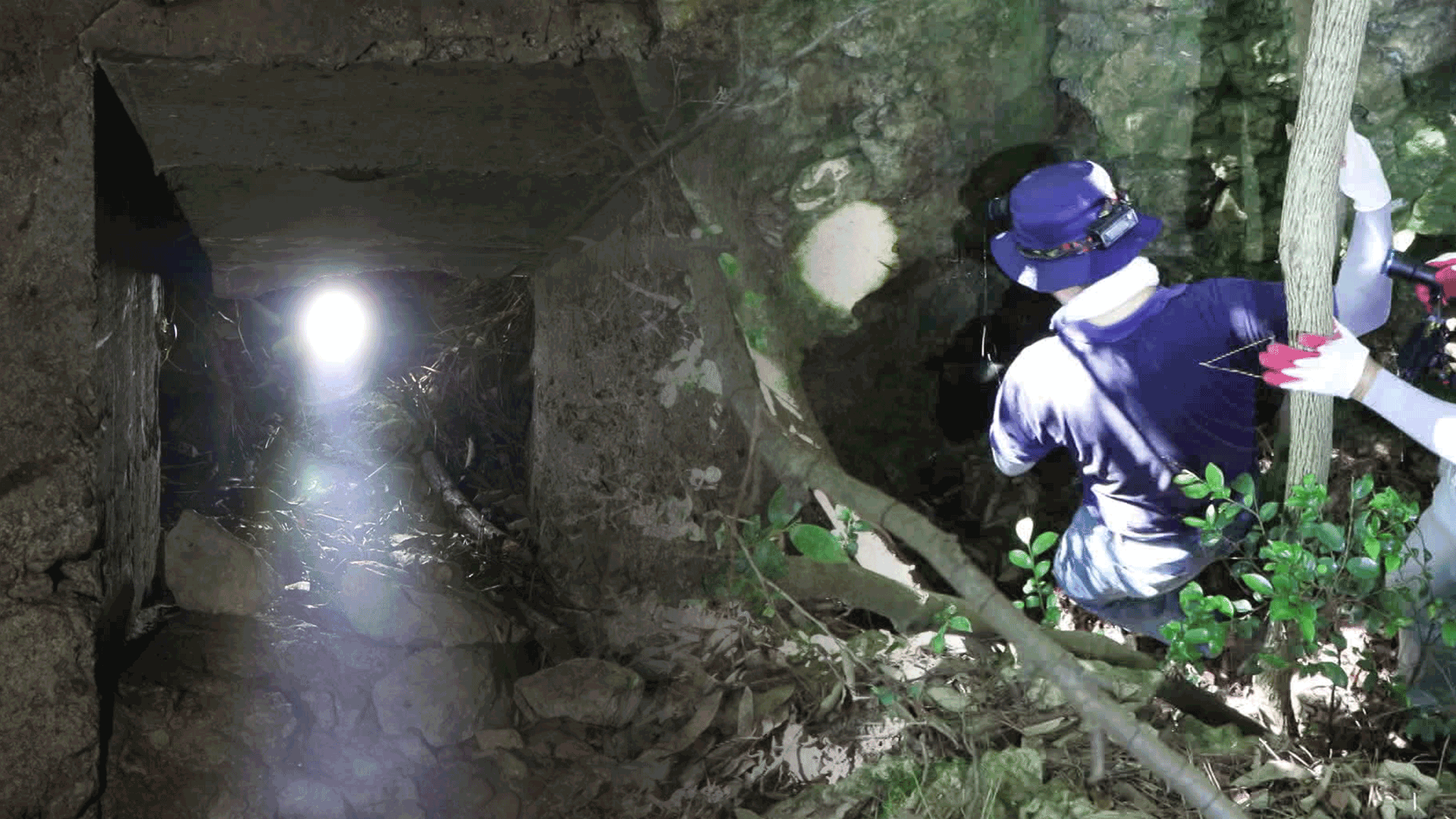
Yongchuldo, a small island located along the sea route to Mokpo Port.
After 30 minutes of pushing through thick vegetation, a cave entrance appears—so narrow that one must crouch to enter.
Inside is a wide concrete structure.
Facing the sea, gun ports are positioned between two-meter-thick walls—apparently designed to withstand aerial bombardment while targeting approaching enemies.
Next, we rerouted by boat to Gasado, a small island off the coast of Jindo.
Past a mining tunnel built by the Japanese and through the overgrowth, we discover a half-cylindrical cave.
This was once a Japanese military command post. Dynamite holes drilled into the rock are still visible.
[Kikuchi Minoru/Co-Representative, Japan War Ruins Preservation Network: “This dynamite came from the Iwahana Army Explosives Plant. The army and navy had serious conflicts, so they didn’t share supplies with each other.”]
Our team discovered five more military positions in the area surrounding the cave.
In Muan County, where a Japanese airfield once stood, an old Japanese concrete bunker now serves as a makeshift storage shed beside a field.
[Shin Woong-joo/Professor of Architecture, Chosun University: “They laid straw mats before pouring the concrete. That made it easier to remove the formwork later.”]
KBS also obtained over 100 pages of defense position maps drawn by the Japanese Army’s 150th Division, showing over 400 fortified sites across the southwestern coastal and inland regions of Jeolla Province.
Most of the structures we discovered matched the locations on those wartime military maps.
These installations were heavily concentrated along the coast, suggesting Japan turned the southwest coast into a military fortress in preparation for a possible landing by the Allies.
[Wakatsuki Shinji/Head, Matsue Chapter, Japan Postwar History Forum: “The 150th Division was created specifically for a homeland decisive battle. Japan anticipated that if the U.S. invaded the Japanese mainland, they would simultaneously send troops to Korea.”]
Despite these widespread remnants of Japan's efforts to militarize Korea's southwest coast, no comprehensive survey has been conducted—even 80 years after liberation.
This is Ji Jong-ik, KBS News.
KBS has confirmed that near the end of the Pacific War, Japan constructed extensive military facilities along the southwestern coast of Jeolla Province.
It is believed that the Japanese military fortified this area as a strategic stronghold in anticipation of landing by the Allies.
We followed the traces.
Exclusive report by Ji Jong-ik.
[Report]
Yongchuldo, a small island located along the sea route to Mokpo Port.
After 30 minutes of pushing through thick vegetation, a cave entrance appears—so narrow that one must crouch to enter.
Inside is a wide concrete structure.
Facing the sea, gun ports are positioned between two-meter-thick walls—apparently designed to withstand aerial bombardment while targeting approaching enemies.
Next, we rerouted by boat to Gasado, a small island off the coast of Jindo.
Past a mining tunnel built by the Japanese and through the overgrowth, we discover a half-cylindrical cave.
This was once a Japanese military command post. Dynamite holes drilled into the rock are still visible.
[Kikuchi Minoru/Co-Representative, Japan War Ruins Preservation Network: “This dynamite came from the Iwahana Army Explosives Plant. The army and navy had serious conflicts, so they didn’t share supplies with each other.”]
Our team discovered five more military positions in the area surrounding the cave.
In Muan County, where a Japanese airfield once stood, an old Japanese concrete bunker now serves as a makeshift storage shed beside a field.
[Shin Woong-joo/Professor of Architecture, Chosun University: “They laid straw mats before pouring the concrete. That made it easier to remove the formwork later.”]
KBS also obtained over 100 pages of defense position maps drawn by the Japanese Army’s 150th Division, showing over 400 fortified sites across the southwestern coastal and inland regions of Jeolla Province.
Most of the structures we discovered matched the locations on those wartime military maps.
These installations were heavily concentrated along the coast, suggesting Japan turned the southwest coast into a military fortress in preparation for a possible landing by the Allies.
[Wakatsuki Shinji/Head, Matsue Chapter, Japan Postwar History Forum: “The 150th Division was created specifically for a homeland decisive battle. Japan anticipated that if the U.S. invaded the Japanese mainland, they would simultaneously send troops to Korea.”]
Despite these widespread remnants of Japan's efforts to militarize Korea's southwest coast, no comprehensive survey has been conducted—even 80 years after liberation.
This is Ji Jong-ik, KBS News.
■ 제보하기
▷ 카카오톡 : 'KBS제보' 검색, 채널 추가
▷ 전화 : 02-781-1234, 4444
▷ 이메일 : kbs1234@kbs.co.kr
▷ 유튜브, 네이버, 카카오에서도 KBS뉴스를 구독해주세요!
- [Exclusive] Japan’s fortress in Korea
-
- 입력 2025-08-15 23:43:23
[Anchor]
KBS has confirmed that near the end of the Pacific War, Japan constructed extensive military facilities along the southwestern coast of Jeolla Province.
It is believed that the Japanese military fortified this area as a strategic stronghold in anticipation of landing by the Allies.
We followed the traces.
Exclusive report by Ji Jong-ik.
[Report]
Yongchuldo, a small island located along the sea route to Mokpo Port.
After 30 minutes of pushing through thick vegetation, a cave entrance appears—so narrow that one must crouch to enter.
Inside is a wide concrete structure.
Facing the sea, gun ports are positioned between two-meter-thick walls—apparently designed to withstand aerial bombardment while targeting approaching enemies.
Next, we rerouted by boat to Gasado, a small island off the coast of Jindo.
Past a mining tunnel built by the Japanese and through the overgrowth, we discover a half-cylindrical cave.
This was once a Japanese military command post. Dynamite holes drilled into the rock are still visible.
[Kikuchi Minoru/Co-Representative, Japan War Ruins Preservation Network: “This dynamite came from the Iwahana Army Explosives Plant. The army and navy had serious conflicts, so they didn’t share supplies with each other.”]
Our team discovered five more military positions in the area surrounding the cave.
In Muan County, where a Japanese airfield once stood, an old Japanese concrete bunker now serves as a makeshift storage shed beside a field.
[Shin Woong-joo/Professor of Architecture, Chosun University: “They laid straw mats before pouring the concrete. That made it easier to remove the formwork later.”]
KBS also obtained over 100 pages of defense position maps drawn by the Japanese Army’s 150th Division, showing over 400 fortified sites across the southwestern coastal and inland regions of Jeolla Province.
Most of the structures we discovered matched the locations on those wartime military maps.
These installations were heavily concentrated along the coast, suggesting Japan turned the southwest coast into a military fortress in preparation for a possible landing by the Allies.
[Wakatsuki Shinji/Head, Matsue Chapter, Japan Postwar History Forum: “The 150th Division was created specifically for a homeland decisive battle. Japan anticipated that if the U.S. invaded the Japanese mainland, they would simultaneously send troops to Korea.”]
Despite these widespread remnants of Japan's efforts to militarize Korea's southwest coast, no comprehensive survey has been conducted—even 80 years after liberation.
This is Ji Jong-ik, KBS News.
-
-

지종익 기자 jigu@kbs.co.kr
지종익 기자의 기사 모음
-
이 기사가 좋으셨다면
-
좋아요
0
-
응원해요
0
-
후속 원해요
0
오늘의 핫 클릭
실시간 뜨거운 관심을 받고 있는 뉴스
헤드라인


이 기사에 대한 의견을 남겨주세요.